

Road access has changed where trekkers begin and end the walking sections. The lower Marsyangdi Valley between Besisahar and Chame now overlaps significantly with a gravel road, and sections below Muktinath toward Jomsom are road-accessible. A current Annapurna Circuit Trek map with distance helps trekkers distinguish road sections from walking trails before departure, not after arriving at a junction they did not expect.
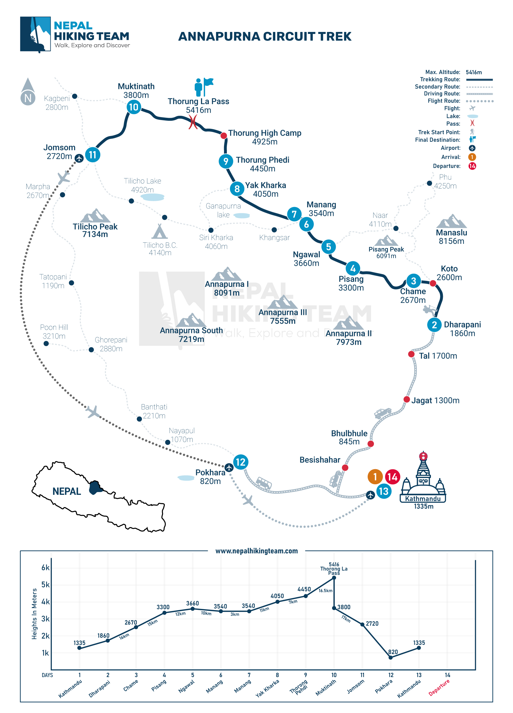
Annapurna Circuit Trek map helps trekkers understand route direction, road sections, NATT trail alternatives, major villages, elevation profile, side trails, and the Thorong La Pass crossing.
This article is an ACT map and navigation guide. It covers route visualization, section maps, Annapurna Circuit trail PDF guidance, Google Maps use, GPX and offline navigation, NATT trails, road sections, elevation awareness, and key places on the circuit map.
Annapurna Circuit Trek Map Overview
| Detail | Information |
|---|---|
| Main route | Besisahar, Dharapani, Chame, Pisang, Manang, Yak Kharka, Thorong Phedi, Thorong La Pass, Muktinath, and Jomsom |
| Highest point | Thorong La Pass at 5,416 m |
| Common modern start | Dharapani or Chame |
| Common modern end | Jomsom or Pokhara |
| Classic route | Besisahar to Nayapul or Pokhara |
| Map use | Route planning, elevation awareness, road sections, NATT trails, PDF planning, and offline navigation |
| Distance note | Total distance varies by route, road use, side trips, and itinerary design |
Are there any recommended apps for navigation on the Annapurna Circuit?
The most recommended navigation apps for the Annapurna Circuit are Mapy.cz and Maps.me, favored for their superior offline functionality. Other reliable options for tracking and planning include Gaia GPS, AllTrails, Komoot, and specialised apps like Trekking in Nepal. All these apps allow downloading map areas, which is essential as connectivity is spotty. Nepal Hiking Team also does provide Hand map for every trekking region, including Annapurna Circuit Trek.
Top Recommended Apps for Annapurna Circuit:
- Mapy.cz: Highly recommended by trekkers for accurate offline maps, including minor trails and contour lines.
- Maps.me: Excellent for offline navigation and finding local points of interest like teahouses.
- Gaia GPS / AllTrails: Popular for route tracking, elevation profiles, and downloading detailed GPX trails.
- Komoot: Useful for planning and tracking, providing detailed metrics like elevation, distance, and time.
- Trekking in Nepal: A specialized app containing detailed, offline-capable routes, itineraries, and points of interest.
- Peakfinder: Excellent for identifying surrounding mountain peaks along the route.
Essential Tips for Navigation:
- Download Offline Maps: Always download the entire Annapurna region map before starting, as Wi-Fi/data is unreliable.
- Carry a Power Bank: GPS usage drains batteries quickly, especially in cold temperatures.
- Paper Map Backup: Many experienced trekkers still recommend carrying a Himalayan Map House paper map, which can be purchased in Kathmandu or Pokhara.
- Look for NATT Trails: Use these apps to follow the New Annapurna Trekking Trails (NATT), which help you avoid walking on roads
How detailed are the Annapurna Circuit maps available online?
Online Annapurna Circuit maps are highly detailed, providing essential tools for navigation, such as village locations, teahouses, and crucial topographical information. They often include altitude profiles, highlighting daily elevation gains to assist with acclimatization and side trips like Tilicho Lake. Common sources like Nepal Hiking team offer high-quality, zoomable A3 maps covering the entire route.
Key Features of Online Maps:
- Detailed Topography: These maps show crucial elevation changes, such as the climb to Thorong La Pass at 5,416m.
- Route Highlights: Maps delineate the main circuit, the New Annapurna Trekking Trail (NATT) that avoids roads, and key villages like Manang and Muktinath.
- Essential Info: They often mark, as shown in the Sherpana interactive map, potential, landslide zones, suspension bridges, and viewpoints.
- Accessibility: Digital maps are easily accessible, allowing for pre-trip planning or mobile, offline use.
- For the most precise trekking, consider using a physical map, found in this Nepal Hiking Team Annapurna Circuit Trek Map guide, in conjunction with a mobile app for optimal safety and planning.
What Is the Annapurna Circuit Trek Map?
The Annapurna Circuit Trek map shows the route circling the Annapurna massif in northwest Nepal, connecting Besisahar, Dharapani, Chame, Pisang, Manang, Yak Kharka, Thorong Phedi, Thorong La Pass, Muktinath, Jomsom, and Pokhara.
It helps trekkers understand route direction, elevation profile, altitude gain, road sections, walking trails, NATT alternative paths, side trails, and common exit points. The map also shows how optional routes to Tilicho Lake, Nar Phu Valley, Ice Lake, Ghorepani, and Poon Hill connect with the main Annapurna Circuit route.
Following the Annapurna Circuit route map, the trek moves northeast along the Marsyangdi River through Dharapani, Chame, Pisang, and Manang before crossing Thorong La Pass at 5,416 m. The trail then descends to Muktinath and continues through the Kali Gandaki Valley toward Jomsom, with extensions available toward Tatopani, Ghorepani, Poon Hill, and Pokhara.
An updated Annapurna Circuit Trek map is important because road access has changed the old classic circuit. Modern maps show which sections remain walking trails, which sections now follow road access, and where New Annapurna Trekking Trail routes provide quieter road-free alternatives.
Annapurna Circuit Trek Overview
| Map Feature | Why It Matters |
|---|---|
| Main trekking route | Shows the direction, villages, and order of the circuit from start to finish |
| Road sections | Helps trekkers identify where jeep roads overlap with or replace old walking trails |
| NATT trail alternatives | Shows road-free walking options in lower sections where roads now run |
| Elevation profile | Supports acclimatization planning and helps trekkers understand altitude gain per section |
| Side trails | Marks routes to Tilicho Lake, Ice Lake, Nar Phu Valley, and Ghorepani |
| Exit routes | Shows options to exit at Jomsom by road, flight, or continue toward Pokhara |
| Thorong La Pass crossing | Identifies the highest point, ascent direction, and descent toward Muktinath |
| Major villages | Marks overnight stops, teahouse locations, and acclimatization hubs |
Annapurna Circuit Map vs Annapurna Region Map
The terms are often used interchangeably, but an Annapurna region map and an Annapurna Circuit Trek map cover different areas.
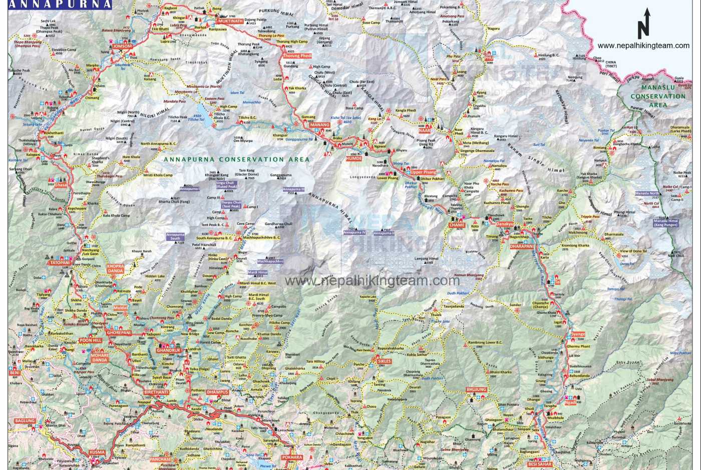
The map of the Annapurna region covers a much wider area including Annapurna Base Camp, Mardi Himal, Ghorepani Poon Hill, Khopra Ridge, Tilicho Lake, Nar Phu Valley, and the full network of trekking routes across the Annapurna Conservation Area. This broader Annapurna trekking map suits trekkers planning multi-route itineraries or wanting to understand how different trails connect across the region.
The Annapurna trek map for the Circuit focuses specifically on the route around the Annapurna massif: through the Marsyangdi Valley, over Thorong La Pass, through Muktinath, and down the Kali Gandaki toward Jomsom. It may also show the Tilicho Lake spur and the Nar Phu junction at Koto, but it does not attempt to cover all Annapurna region routes.
When downloading or purchasing a map, check whether it covers the full region or only the Circuit route. For the standard circuit trek, a focused Circuit map is easier to read on the trail than a wide regional overview.
Why the Annapurna Circuit Map Is Usually Followed Anticlockwise
The standard Annapurna Circuit Trek map is designed to be followed anticlockwise, starting in the Marsyangdi Valley on the eastern side and crossing Thorong La Pass from east to west toward Muktinath.
This direction allows a gradual altitude gain through Besisahar, Dharapani, Chame, Pisang, and Manang before the high-altitude push to Thorong La Pass. The steady climb from lower elevations gives the body more time to acclimatize, reducing the risk of altitude sickness before the 5,416 m crossing.
Clockwise travel is possible, but it creates a faster and steeper ascent from the Muktinath side. The western approach to the pass is shorter and gives less acclimatization time at the altitudes that matter most. For most trekkers, the anticlockwise route shown on standard Annapurna Circuit Trek maps is safer and more practical.
Annapurna Circuit Route Map: Section-by-Section Guide
Full Annapurna Circuit Route Map
The full route on the Annapurna Circuit map begins with a drive from Kathmandu to Besisahar, the historical trailhead. From Besisahar, the trekking route heads northeast through Dharapani, Chame, Pisang, and Manang. After acclimatizing in Manang, the route continues to Yak Kharka, Thorong Phedi, and over Thorong La Pass at 5,416 m. The descent leads to Muktinath and down the Kali Gandaki Valley to Jomsom.
Maps show different end points depending on whether trekkers finish at Jomsom, Tatopani, Nayapul, or Pokhara. Modern itineraries often use jeep transfers to skip road-heavy lower sections, particularly between Besisahar and Dharapani or Chame. As a result, many trekkers today walk only the upper sections shown on the map, starting at Dharapani or Chame and ending at Jomsom. The map helps identify exactly where the meaningful walking sections begin and where road transfers become the practical choice.
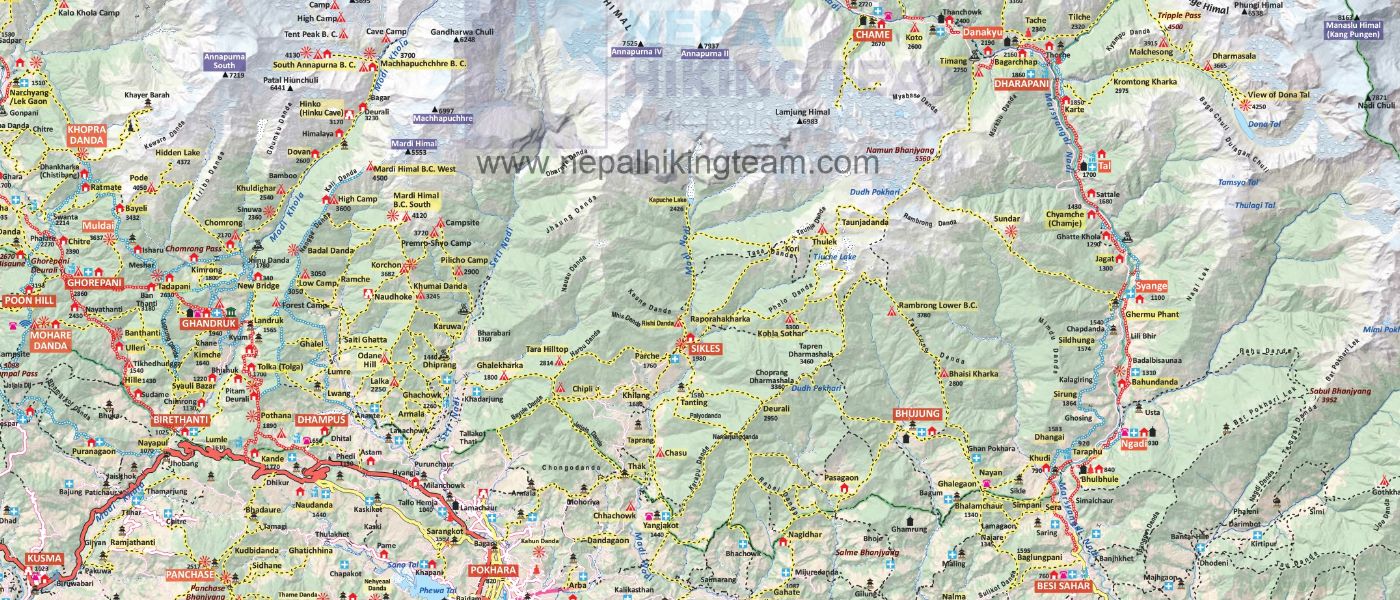
Besisahar or Dharapani to Chame Map
This lower section follows the Marsyangdi River through Bhulbhule, Ngadi, Jagat, Chamje, and Dharapani before reaching Chame at 2,670 m. The map shows the terrain shifting from terraced farmland and subtropical forest to rockier ground as elevation increases.
Chame is the central administrative Headquater of Manang, explore more about Chame village during Annapurna Circuit Trek in our detailed blog.
Road construction has heavily affected this section, and the map should be read with that in mind. Much of the trail now overlaps with or runs parallel to a gravel road. Many trekkers take a jeep from Besisahar or Jagat to Dharapani or Chame to skip road walking. An updated map that clearly distinguishes road sections from NATT walking alternatives helps trekkers decide where to ride and where to walk.
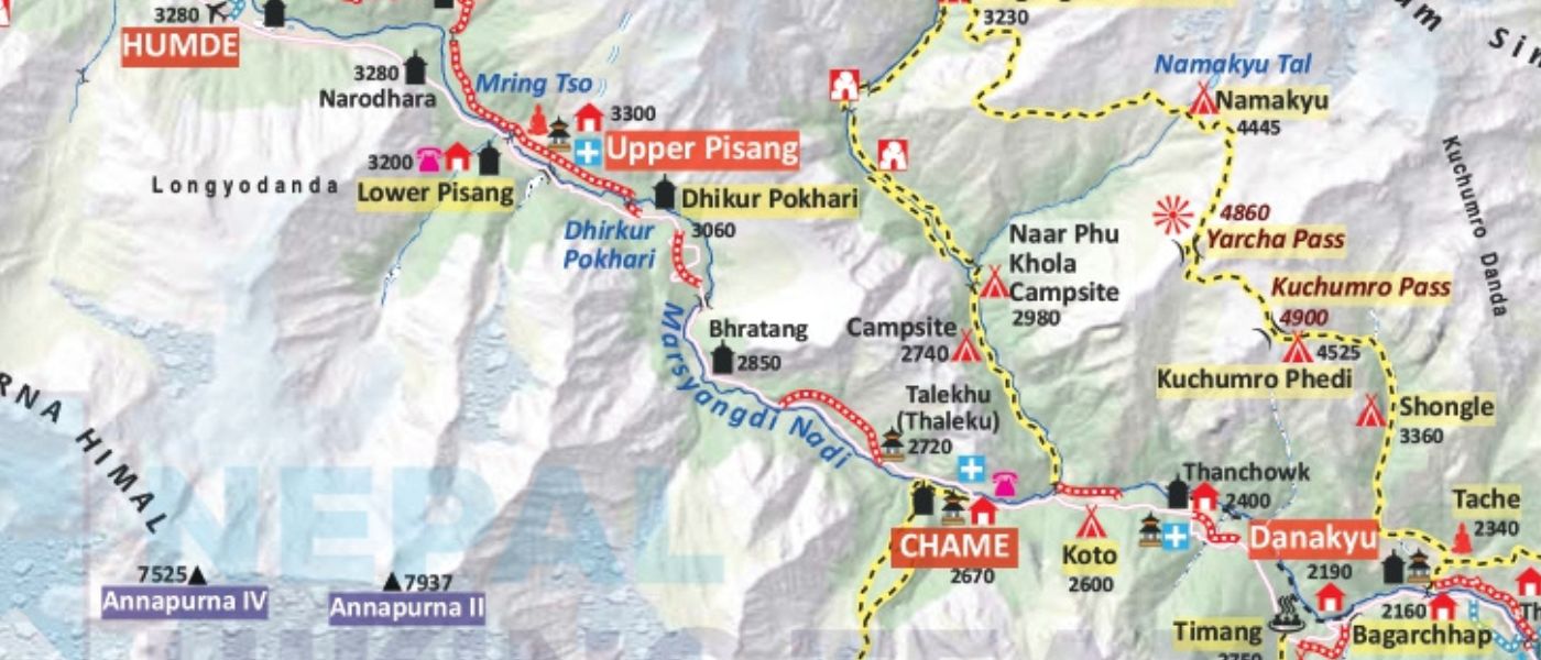
Chame to Pisang Map
From Chame, the route moves into alpine terrain with a noticeable change in vegetation and temperature. The trail follows the river valley through pine and birch forest before opening into wider views of Lamjung Himal and Annapurna II.
This section on the Annapurna Circuit trail map still retains a traditional walking trail feel and offers a relatively road-free experience compared to the lower sections. The trail crosses suspension bridges, passes through small settlements, and gains elevation steadily before reaching Pisang at around 3,200 m. The map is useful here for identifying bridge crossings and trail junctions where the path splits briefly before rejoining.
Pisang to Manang Map
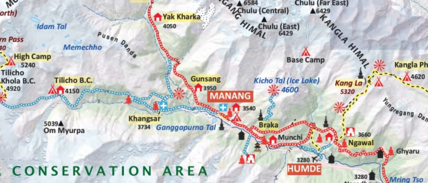
From Pisang, the map shows two parallel routes toward Manang. The upper route climbs through Ghyaru and Ngawal, offering ridge walking with direct views of Annapurna II, Annapurna III, and Gangapurna. The lower route follows the valley floor through Humde, passing a small airstrip before reaching Braga Monastery and then Manang.
The upper route is longer and involves more elevation change, but the scenery is exceptional. The lower route is shorter and easier. Both routes are shown on most detailed Annapurna Circuit trekking maps. Trekkers often use one direction on the way to Manang and the other for an acclimatization day hike, making this map section particularly useful for itinerary planning.
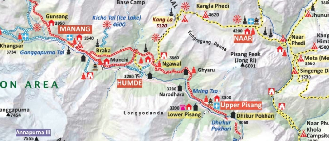
Manang Acclimatization and Side Trails Map
Manang at 3,540 m is the primary acclimatization stop before the Thorong La Pass crossing. Most trekkers spend at least one full day here, and the map around Manang shows several acclimatization hike options that are worth planning before departure.
There are alot of things that can be done in Manang. Review our blog on things to do during acclimatisation day in Manang.
The trail to Gangapurna Lake sits above the village and provides a short but useful elevation gain. Ice Lake, higher above Manang, is a more demanding half-day hike with strong acclimatization benefit. Braga Monastery lies close to the trail between Pisang and Manang. The map also shows the trail toward Khangsar and the junction branching off toward Tilicho Lake. Identifying these trails on the map before arriving in Manang helps trekkers use their rest day effectively.
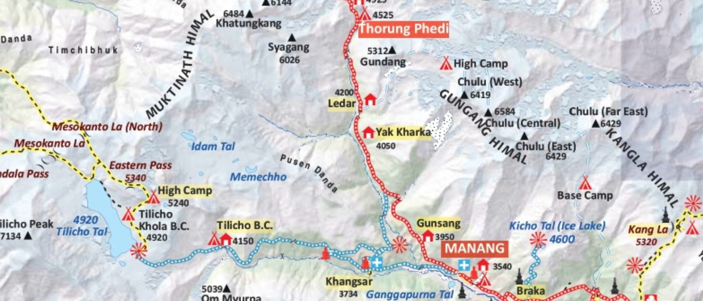
Manang to Yak Kharka and Thorong Phedi Map
Above Manang, the map shows the trail climbing through open, exposed terrain toward Yak Kharka at around 4,050 m and Thorong Phedi at around 4,525 m. Yak pastures line the route, and vegetation becomes increasingly sparse. The map distance here may look short, but thin air and colder temperatures demand a slower pace than lower sections.
Landslide-prone areas appear in some stretches, particularly after heavy rainfall or snowfall. The map helps trekkers identify these sections in advance, but local updates on current trail condition should always take priority over map assumptions. Do not rush this section based on distance alone.
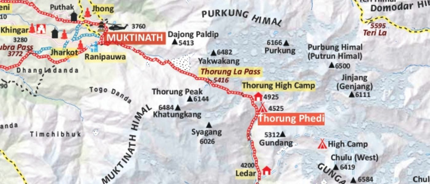
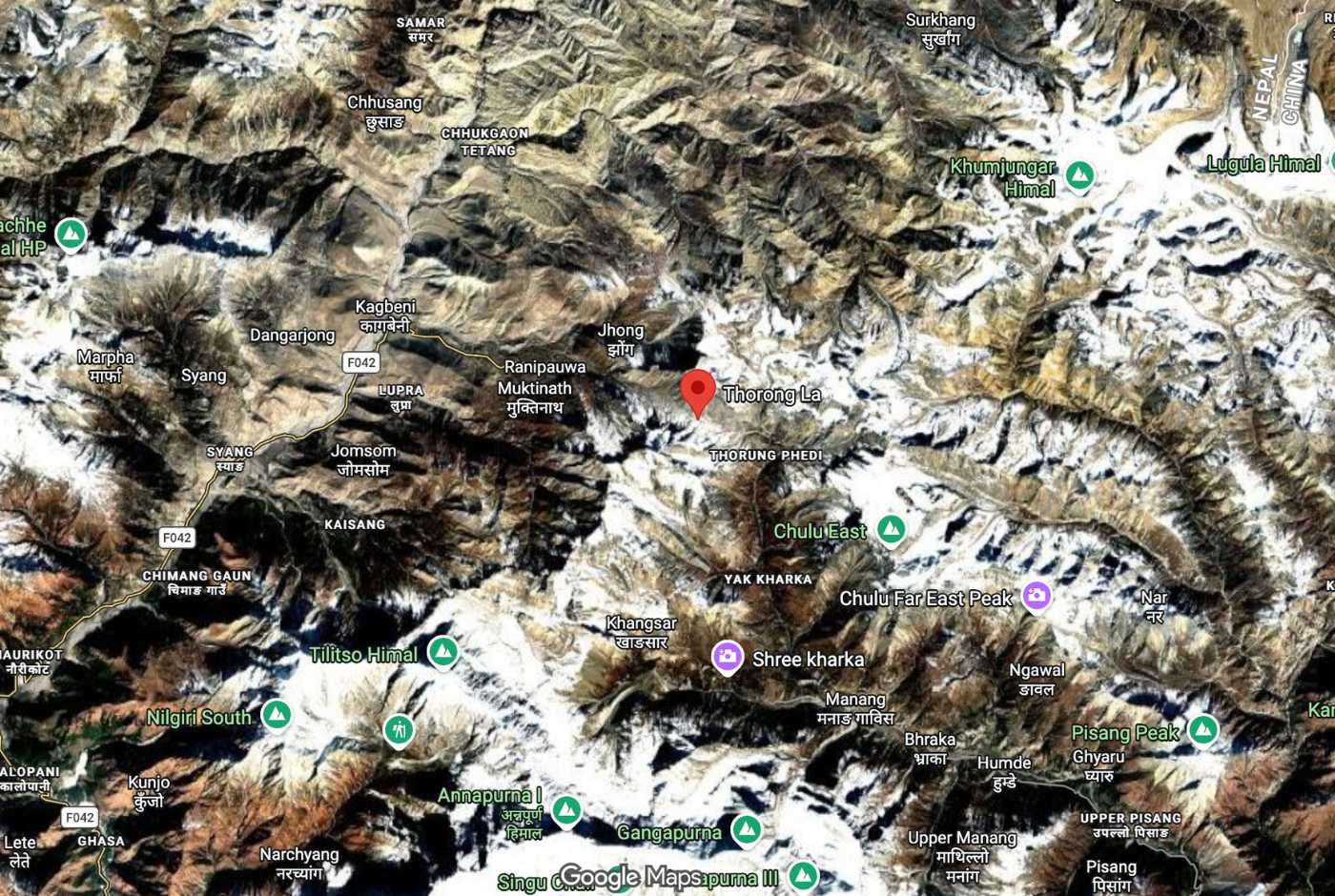
Thorong Phedi to Thorong La Pass and Muktinath Map
Thorong La Pass at 5,416 m is the highest and most demanding point on the entire Annapurna Circuit map. Most trekkers leave Thorong Phedi or High Camp between 4:00 and 5:00 AM to reach the pass before strong afternoon winds arrive.
The ascent from Thorong Phedi is steep and exposed. Snow can be present year-round, and conditions change quickly at this altitude. Wind exposure increases significantly near the summit. The descent to Muktinath is long, dropping over 1,600 m through open, rocky terrain before arriving at around 3,760 m.
The Thorong La Pass map section should be studied carefully before the crossing. However, map reading alone is not sufficient here. Weather conditions, guide advice, and an honest assessment of how your body is responding to altitude matter more than map distance on this section. Trekkers experiencing any altitude sickness symptoms should not attempt the pass without seeking local guidance first.
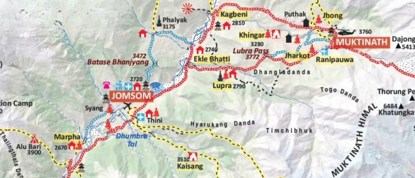
Muktinath to Jomsom or Pokhara Map
From Muktinath, the Muktinath to Jomsom map shows the descent through Ranipauwa, the Lupra route past Ekle Bhatti, and the Kali Gandaki Valley floor to Jomsom at around 2,720 m. The valley is known for strong afternoon winds that pick up sand and dust from the dry riverbed, making afternoon walking uncomfortable.
Road sections run throughout this lower Mustang area. Many trekkers combine walking with jeep transport based on time and conditions. From Jomsom, options include a jeep road south through Marpha, Ghasa, Tatopani, Beni, and onward to Pokhara, or a direct flight from Jomsom airport. The map helps identify where the road and trail diverge and where trekkers can choose walking sections that avoid vehicle traffic.
How Road Access Changed the Annapurna Circuit Map
The Annapurna Circuit Trek has changed because roads now reach many lower sections that were once remote walking trails. Road access affects the route from Besisahar toward Dharapani and Chame on the eastern side. Roads also affect the Muktinath, Jomsom, Tatopani, and Beni sections on the western side.
Older maps often do not reflect this reality. A map printed more than five years ago may show trail lines where a gravel road now runs. Trekkers relying on outdated maps can find themselves walking alongside vehicles on sections they expected to be quiet forest paths.
The Annapurna Circuit is not a dead route. It has evolved into a more flexible trek where map reading helps trekkers choose the best walking sections. Many trekkers now combine jeep transfers, NATT alternative trails, and high-altitude walking to build an itinerary that prioritizes quality walking where the scenery and trail experience are strongest.
The trek still works. The upper sections from Chame to Manang, the high-altitude approach to Thorong La Pass, the pass crossing itself, and the descent to Muktinath remain powerful trekking experiences. Reading an updated Annapurna Circuit map helps trekkers invest walking days where they count most.
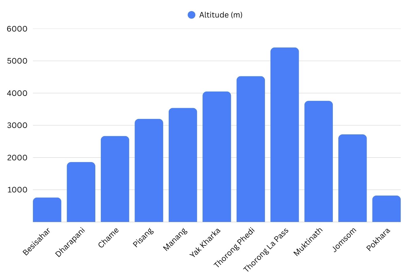
Annapurna Circuit Elevation Map
The Annapurna Circuit elevation map shows how altitude changes across the full route. Understanding the elevation profile supports acclimatization planning and helps trekkers recognize where the hardest climbing occurs relative to overall trail distance.
The climb is gradual from Besisahar to Manang, then steepens sharply toward Thorong La Pass. The descent to Muktinath is rapid, dropping over 1,600 m in a single day. From Muktinath to Jomsom and Pokhara, elevation falls steadily. The Annapurna Circuit altitude map is most useful when read alongside acclimatization guidelines, not as a standalone distance reference.
| Location | Altitude |
|---|---|
| Besisahar | 760 m |
| Dharapani | 1,860 m |
| Chame | 2,670 m |
| Pisang | around 3,200 m |
| Manang | 3,540 m |
| Yak Kharka | around 4,050 m |
| Thorong Phedi | around 4,525 m |
| Thorong La Pass | 5,416 m |
| Muktinath | around 3,760 m |
| Jomsom | around 2,720 m |
| Pokhara | 822 m |
Oxygen levels drop significantly above 3,500 m. By Thorong La Pass, available oxygen is roughly half of what it is at sea level. The Annapurna Circuit elevation profile makes this gradient visible and helps trekkers plan rest days, pacing, and the timing of the high-altitude sections.
How to Read the Annapurna Circuit Map Correctly
The Annapurna Circuit map rewards careful reading. Distance figures alone do not tell the full story of any section on this trek.
Above Manang, a 6-kilometre section at high altitude can feel harder and take longer than a 15-kilometre section at lower elevation. A short section above 4,000 m can require the same time and energy as an extended lower-valley walk. Elevation gain, thin air, wind, temperature, and trail surface all affect how long a section takes. When reading the map, focus on contour lines and elevation markers as much as the distance between points.
Road sections and walking trails sometimes overlap on older maps. What appears to be a clear trekking trail may now run alongside or directly on a gravel road. NATT routes may not appear on all maps, particularly older printed versions. The Thorong La Pass section requires weather awareness and guide advice, not map confidence alone. Snow, wind, and altitude judgment matter more than the elevation figures printed on the map.
Focus on elevation gain and trail condition when reading the Annapurna Circuit map above Manang, distance figures alone can be seriously misleading at high altitude.
Annapurna Circuit Map PDF
An Annapurna Circuit Trek map PDF is useful before arrival in Nepal. A PDF map allows route review on screen or in print, showing the full circuit, elevation profile, overnight stops, side trips, and key landmarks without needing an internet connection during planning.
PDF maps for the Annapurna Circuit support early planning well. They help trekkers understand the shape of the route, identify acclimatization stops, and compare NATT versus road sections before finalizing an itinerary. For those working with a trekking company, a PDF map is a useful reference during pre-trek briefings in Kathmandu or Pokhara.
PDF maps are static documents. They cannot show real-time landslides, seasonal snow coverage, current road construction, or recent trail condition changes. A PDF downloaded a year ago may already be outdated in lower sections where road expansion continues. Use a PDF map for planning and orientation, then confirm current conditions locally once in Nepal.
You can download Nepal Hiking Team's Annapurna Circuit Trekking Map here: DOWNLOAD PDF ANNAPURNA CIRCUIT
Planning tip: Download or save the Annapurna Circuit map PDF before leaving Kathmandu or Pokhara. Internet access becomes less reliable after Chame, and offline access is useful for checking the route, villages, elevation, and side trails during the trek.
Annapurna Circuit Trek Map on Google Maps
Google Maps for the Annapurna Circuit Trek is a useful starting point for understanding the general geography of the route. It clearly shows major villages, road access points, rivers, and how the circuit connects Besisahar on the east side to Jomsom on the west side.
The Annapurna Circuit Google map helps trekkers visualize the circuit shape before departure and identify which towns are reachable by road. This is useful when planning jeep transfers and understanding where the driving section ends and the walking section begins.
Google Maps has real limitations for trekking navigation. It may not accurately show NATT walking trails, local footpaths, landslide detours, suspension bridge crossings, or seasonal route changes. Trail data for remote sections above Manang is often incomplete. Do not rely on Google Maps as your primary navigation tool on the trail.
Annapurna Circuit GPX Map and Offline Navigation
An Annapurna Circuit GPX map can help trekkers follow the route on offline navigation apps. GPX tracks show trail direction, village locations, approximate road sections, and side route junctions. Loaded into a compatible app, a GPX file is useful for staying oriented in areas where signage is limited or weather reduces visibility.
Annapurna Circuit offline maps and GPX tracks should be downloaded before leaving Kathmandu or Pokhara. Mobile signal and internet access become unreliable after Chame. Dedicated trekking apps that support offline use with OpenStreetMap data or Nepal-specific trail layers perform better than Google Maps in remote sections.
A saved Annapurna Circuit GPS map is a planning and orientation tool, not a replacement for current trail judgment. GPX tracks can become outdated. Landslides, new roads, bridge changes, snow coverage, and local detours can all make a recorded track inaccurate. Always confirm current trail conditions with guides, teahouse owners, and other trekkers regardless of what the GPX track shows.
Best Annapurna Circuit Trek Map: What Should It Show?
A good Annapurna Circuit trekking map covers the practical needs of a trekker from pre-departure planning through on-trail navigation. When evaluating any map, check whether it includes the following:
- Main trekking route from Besisahar to Jomsom or Pokhara
- Road sections clearly distinguished from walking trails
- NATT trail alternatives in lower sections
- Villages and overnight stops with approximate altitude
- Rivers and major bridge crossing locations
- Elevation profile showing altitude gain and loss by section
- Thorong La Pass with elevation marking
- Side trails including Tilicho Lake, Ice Lake, and Nar Phu approaches
- Emergency exit points and evacuation routes
- Optional extensions toward Tatopani, Ghorepani, and Poon Hill
- Key acclimatization stops, particularly around Manang
- Landslide-prone or high-risk sections where noted
- GPX or offline compatibility if the map is in digital format
NATT Trails vs Road Sections on the Annapurna Circuit Map
NATT stands for New Annapurna Trekking Trails. These routes were developed to give trekkers road-free walking alternatives on sections of the Annapurna Circuit where road construction has altered the original trail experience.
Annapurna Circuit NATT trails run through parts of the lower Marsyangdi Valley, offering forest paths and river-edge routes that bypass the gravel road. Where they exist, NATT alternatives provide a quieter and more authentic trekking experience than walking alongside vehicle traffic.
Roads now affect a substantial portion of the lower circuit. The Annapurna Circuit road sections between Besisahar and Chame are significant, and roads also exist around Manang and after Muktinath. An Annapurna Circuit map with road sections clearly marked helps trekkers see where the road and trail overlap and where NATT options diverge.
Older maps do not show current Annapurna Circuit road vs trail conditions accurately. A map printed five or more years ago may show a forest trail that now runs parallel to a busy road. This gap between map and ground reality is why an updated Annapurna Circuit map matters. An Annapurna Circuit map with NATT trails helps trekkers choose walking days where road-free terrain is still possible.
Many trekkers now combine jeep transfers, NATT sections, and trail walking to build itineraries that prioritize quality over total distance covered on foot. Understanding the road versus trail picture from the map before departure allows better planning and fewer surprises on the ground.
Where the Annapurna Circuit Map Can Be Misleading
Maps are planning tools, and every map has limits. On the Annapurna Circuit, several situations can cause map information to mislead trekkers if taken at face value.
Old maps show trails that now overlap with roads. Road construction between Besisahar and Chame has moved faster than many map publishers update. Start and end points vary between itineraries, so distances shown on one map may not match the actual distance walked on a customized route. Google Maps may default to road routing rather than walking trail routing in areas with vehicle access.
Landslides can close trails and force detours that no map can predict. Snow can close Thorong La Pass regardless of what the elevation profile suggests. Bridge conditions change. Seasonal changes affect trail conditions in ways that static map data cannot capture.
Important map note: No Annapurna Circuit map is fully accurate in real time. Road construction, landslides, snow conditions, local detours, bridge changes, and seasonal trail changes can affect the route. Always confirm current trail conditions locally before making route decisions.
Annapurna Circuit Map Variations
Tilicho Lake Side Trip
The Tilicho Lake side trip branches from the main circuit near Manang or Khangsar and follows a separate trail through Siri Kharka and Tilicho Base Camp to Tilicho Lake at around 4,919 m. On the map, this route is shown as a spur off the main circuit, adding two to three days and rejoining near Yak Kharka. Most detailed circuit maps include this branch.
Nar Phu Valley Route
The Nar Phu Valley route branches from the main circuit at Koto, a small village between Dharapani and Chame. On the map, it follows the Nar Khola valley into a restricted area requiring a special permit. This route does not appear on basic circuit maps and requires a specialized trekking map covering the restricted zone.
Ghorepani Poon Hill Extension (Classic Annapurna Circuit Trek)
Trekkers finishing at Jomsom can continue south through Marpha, Ghasa, and Tatopani toward Ghorepani and Poon Hill before descending to Nayapul and Pokhara. On the map, this extension connects the Circuit to the Ghorepani route and is shown on regional Annapurna trekking maps.
Upper Mustang Add-on
From Jomsom, a restricted permit route leads north through Kagbeni into Upper Mustang. On the map, this is a northward branch requiring a separate permit. It is planned as a dedicated extension and needs its own specialized map covering the Upper Mustang restricted area.
Which Parts of the Annapurna Circuit Map Still Feel Like Classic Trekking?
Roads have changed the lower sections of the circuit significantly, but the higher route still delivers a strong and genuine trekking experience. The sections from Chame to Pisang, Pisang to Manang, Manang to Thorong Phedi, the Thorong La Pass crossing, and the descent toward Muktinath remain the core of the circuit and are largely unaffected by road access.
Side hikes from Manang, including Ice Lake and the approach toward Tilicho Lake, add strong trail value and genuine high-altitude remoteness. The map helps trekkers identify where the route still feels remote and exploratory, and where road access has made sections more logistical than experiential. Trekkers who read the map carefully before departure can plan their days to prioritize the walking sections that still carry the spirit of the classic circuit.
Safety and Navigation Tips for the Annapurna Circuit
Good navigation on the Annapurna Circuit combines map knowledge, offline tools, and up-to-date local information. Use the following practices to trek safely and navigate effectively:
- Carry both a printed map and an offline GPS app as backup tools
- Download offline maps and GPX tracks before leaving Kathmandu or Pokhara
- Do not rely solely on Google Maps for trail navigation above Besisahar
- Check weather forecasts locally before attempting the Thorong La Pass crossing
- Confirm road and trail conditions with teahouse owners and guides each morning
- Use NATT trail alternatives where practical to avoid road walking in lower sections
- Do not rush sections above Manang, regardless of map distance; acclimatization in Manang is a must
- Follow guide advice on landslide-prone sections, which can change daily
- Carry enough water between higher settlements where sources may be limited
- Use maps to plan, but update route decisions based on current local information

Annapurna Circuit Trekking Map Concluding Notes
The Annapurna Circuit Trek map is one of the most useful planning tools for understanding the route, elevation profile, road sections, NATT alternatives, side trails, and the Thorong La Pass crossing. It gives a clear overview of how the trail moves from the Marsyangdi Valley to the Kali Gandaki Valley and onward toward Jomsom or Pokhara.
However, a map works best when it is paired with real trail knowledge. Road access, weather, acclimatization needs, lodge availability, and walking conditions can change how the route feels on the ground.
Want to follow this Annapurna Circuit route with confidence? Join Nepal Hiking Team’s Annapurna Circuit Trek and travel with experienced guides who understand the trail, road sections, NATT alternatives, acclimatization stops, and Thorong La Pass crossing.
Post a Comment