

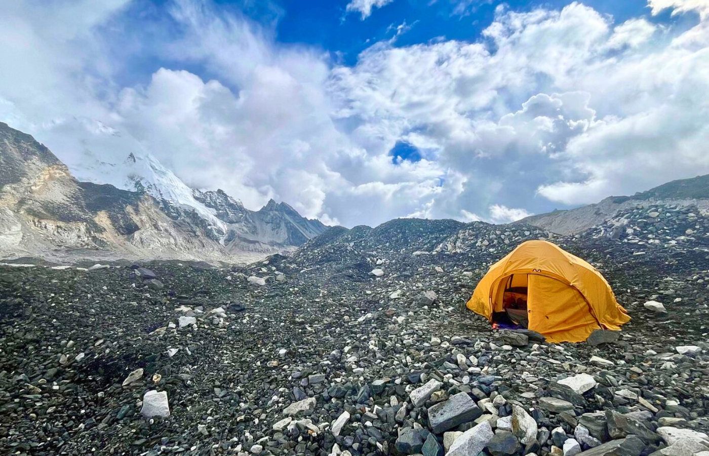
Everest Base Camp, where the scattered tents cling against the gray glacier, white emptiness under the legendary base of the World's Highest peak. The Map of Everest Base Camp is beyond lines on a folded paper. It is a thing of beauty, a roadmap of lived experience, showing every ridge, glacier, river, and a settlement of Sherpas.
By following its contours, thousands and millions have journeyed upward, step by step, to stand at the foothill of the mighty Mount Everest.
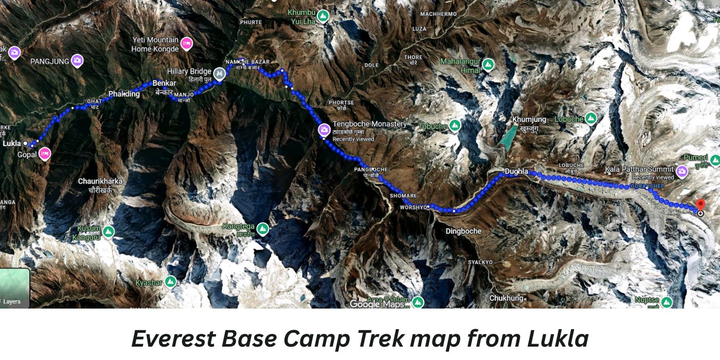
Taking a thrilling flight from Lukla to ascending through the Sherpa market hub of Namche, the spiritual spot Tengboche, the acclimation hike from Dingboche, Lobuche, and Gorak Shep, until you stand at 5,364 meters at Base Camp. Our primary Everest Base Camp trek map with altitude chart elevation guides you along the classic path of Everest. Whether you are starting from a drive to Jiri, Phalpu or a direct flight from Kathmandu to Lukla, this map answers all your queries.
Jiri to Everest Base Camp Trek map with Distance
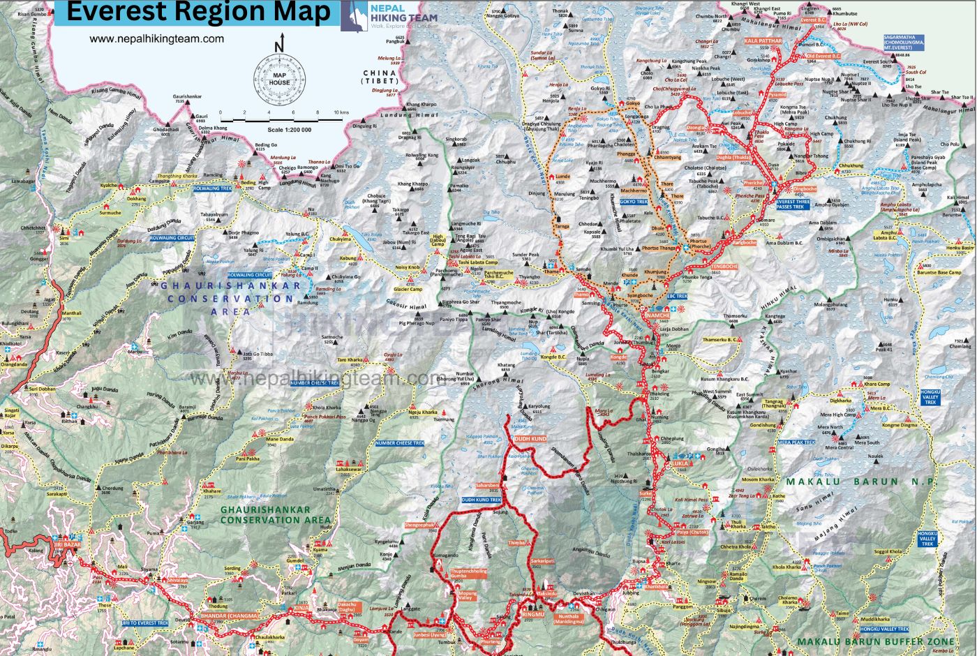
Everest Base Camp Trek Map from Kathmandu
The Everest Base Camp trek begins with a flight from the Kathmandu Valley to Lukla (Tenzing Hillary Airport). Due to traffic congestion at Kathmandu's airport during peak seasons (early March to late May and September to November), most flights to Lukla are rerouted to Manthali Airport in Ramechhap. Whether you choose to drive or by a flight option, you will need to follow the same Everest Base Camp Trek Itinerary Map to reach the Base Camp starting from Phakding.
Everest Base Camp Trek Map Image
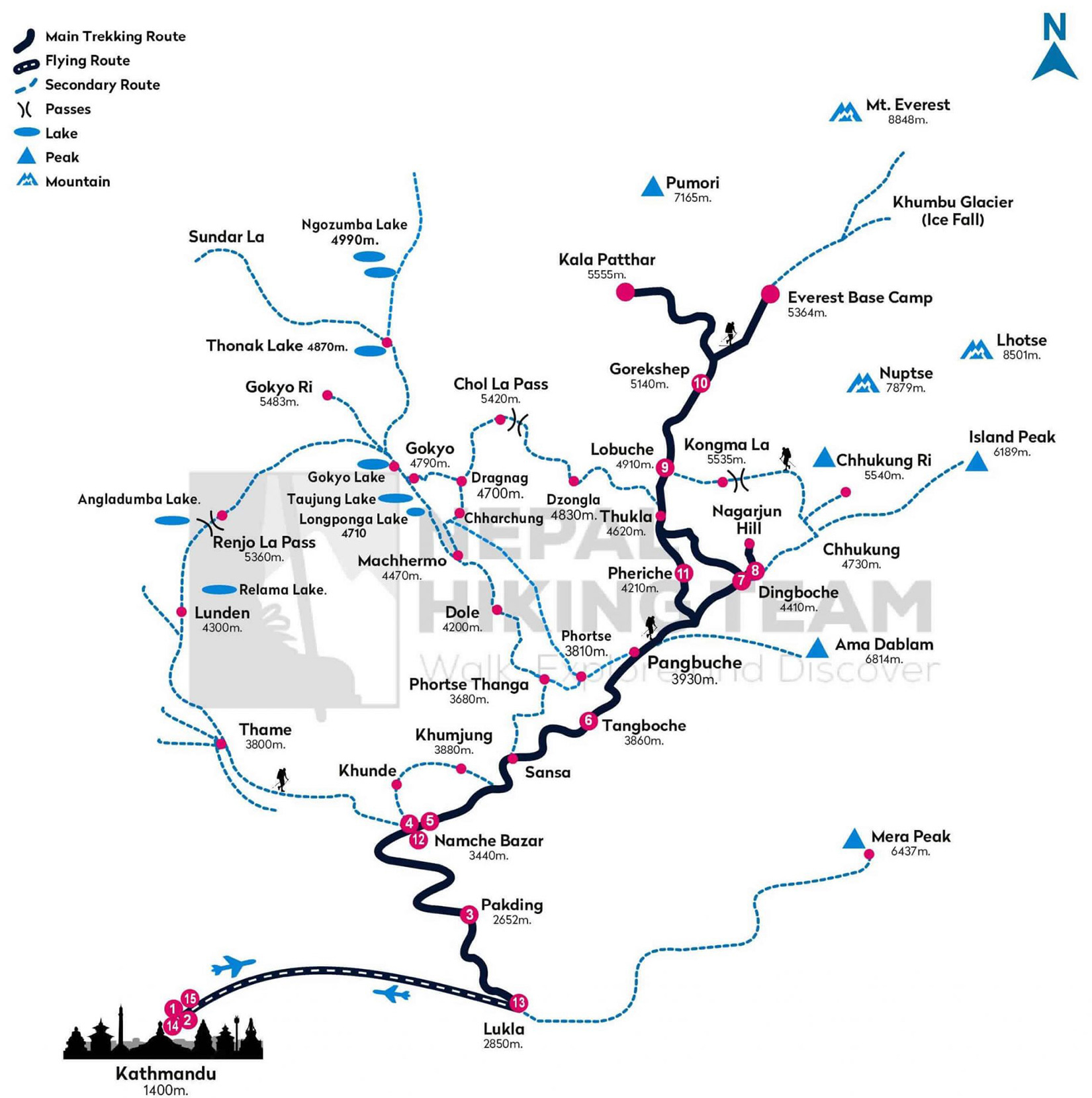
Stage-by-Stage EBC Trek Map With Distance and Altitude Chart
The most practical feature of this guide is the Everest Base Camp trek map with distance. Here we have broken down for daily reality. Note that each distance, duration are written in approximate values. However, it actually depends on your face, trail conditions, fitness level, starting point and amount of time you take rest during the initial and final destination.
The single most precious piece of Khumbu guidance a guide gives is this: ignore the standard hour estimate for kilometers while on the route. Your normal walking time is not judged or calculated by anyone. Walk slowly, listen to your body, and arrive at your destination.
Breakdown of Everest Base Camp Trek Map - Day-by-Day Distance
Jiri Bazar to Lukla Map
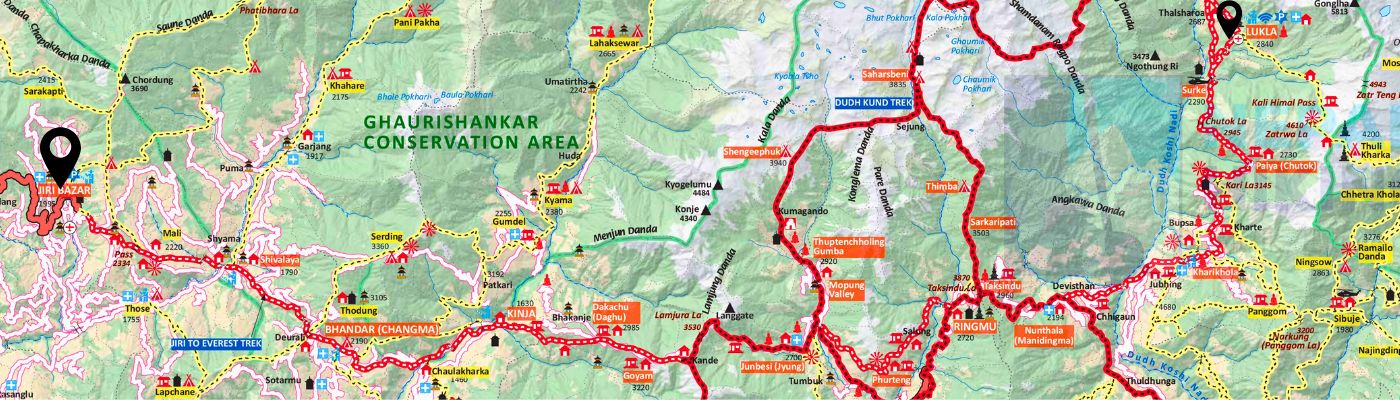
This trek runs from JIRI BAZAR to LUKLA, cutting across the GHAURISHANKAR CONSERVATION AREA. The journey begins at Jiri, situated around 2190 units of elevation, and finishes at Lukla, which sits at 2860 units. Following the red-marked trail, travelers pass through villages like Bhandar, Kinja, Ringmo (2720), and Surkhe (2294). The map shows the route crossing major high points like Thodung (3135) and sections named Bhandar Changma. The path winds through a rugged landscape of valleys and hills, eventually reaching the end point at Lukla.
Lukla to Phakding Map with Distance and Duration
Distance: 8km / 5 miles | Duration: 3 hours | Height Gain: +208m
Everest Base Camp route from Lukla
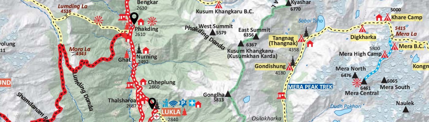
The trekking day from Lukla to Phakding (2610m) is primarily a gentle downhill descent through the Dudh Koshi River valley, allowing trekkers to ease into the high-altitude environment. The journey begins at the airstrip in Lukla and quickly moves through the initial Sherpa settlements, passing Thalsharoa (2687m) and Chheplung (2660m).
The route then continues past the villages of Nurning (2492m) and Ghat before reaching the destination of Phakding. The map highlights that while on the main trail, trekkers are walking near major alternative routes; to the west, the challenging Lumding Danda trail includes the passes of Mora La (4343m) and Lumding La (4516m).
Along the way, trekkers are treated to views of impressive peaks like Kusum Khangkaru (6367m), signaling the serious mountains ahead.
Phakding to Namche Bazaar Map
Phakding to Namche Bazaar | Distance: 10–12km / 6–7.5 miles | Duration: approx. 6 hours | Height Gain: +788m
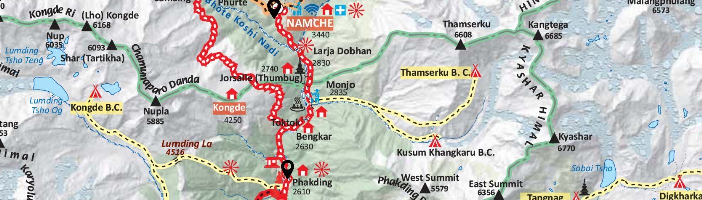
The trek begins at Phakding and follows the valley northward, passing through the small village of Bengkar (2630m). The trail soon continues to the larger settlement of Toktok, which is located just before the gateway to the high mountains. An important alternative route, marked by a dashed yellow line, branches off near Bengkar, leading trekkers east towards the Kusum Khangkaru B.C. and further to the Thamserku B.C..
The major checkpoint on this route is the village of Monjo (2835m), which marks the official entrance to the Sagarmatha National Park (a UNESCO World Heritage Site). After leaving Monjo, the trail descends briefly to Larja Dobhan (2830m), before reaching Jorsalle (Thumbug) (2740m), which is often the last rest or lunch stop before the major climb. It is just after Jorsalle that trekkers cross the final, famous high suspension bridge over the Bhote Koshi Nadi before beginning the long, strenuous ascent to the Sherpa capital.
The final push is a steep, zig-zagging climb that gains significant altitude before finally reaching the bustling, crescent-shaped town of Namche (Namche Bazaar) (3440m), where views of massive peaks like Thamserku (6608m) and Kangtega (6685m) dominate the horizon.
Namche Bazaar to Tengboche Route Map with Distance
Namche to Everest View Hotel (via Syangboche and return) | Distance: 3–4km / 1.8–2.5 miles | Duration: 3–4 hours | Height Gain: +522m
Namche Bazaar to Tengboche | Distance: 10–11km / 6–6.8 miles | Duration: 5 hours | Height Gain: +420m
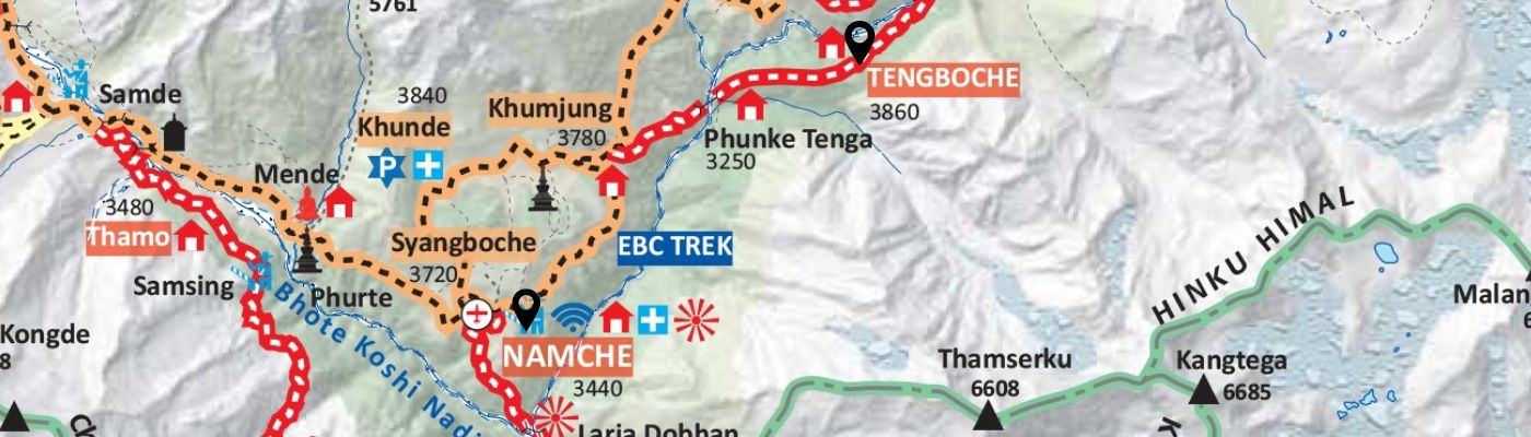
The trek from Namche to Tengboche (3860m) begins with a short, steep climb out of the Namche amphitheater.
Trekkers usually stay two nights in Namche Bazar for acclimatization. They will first pass by the alternative path leading up toward Syangboche (3720m) and the villages of Khunde (3840m) and Khumjung (3780m), and popular Everest View Hotel, which are popular side trips for acclimatisation.
The main EBC Trek trail then follows a generally flat, high contour path, offering views of the great Himalayan peaks. The path descends steeply to Phunke Tenga (3250m), before beginning a steady and long uphill climb to reach the final destination. Tengboche is famously crowned by its Monastery, set against the backdrop of mountains including Thamserku (6608m) and Kangtega (6685m).
Tengboche to Dingboche Map
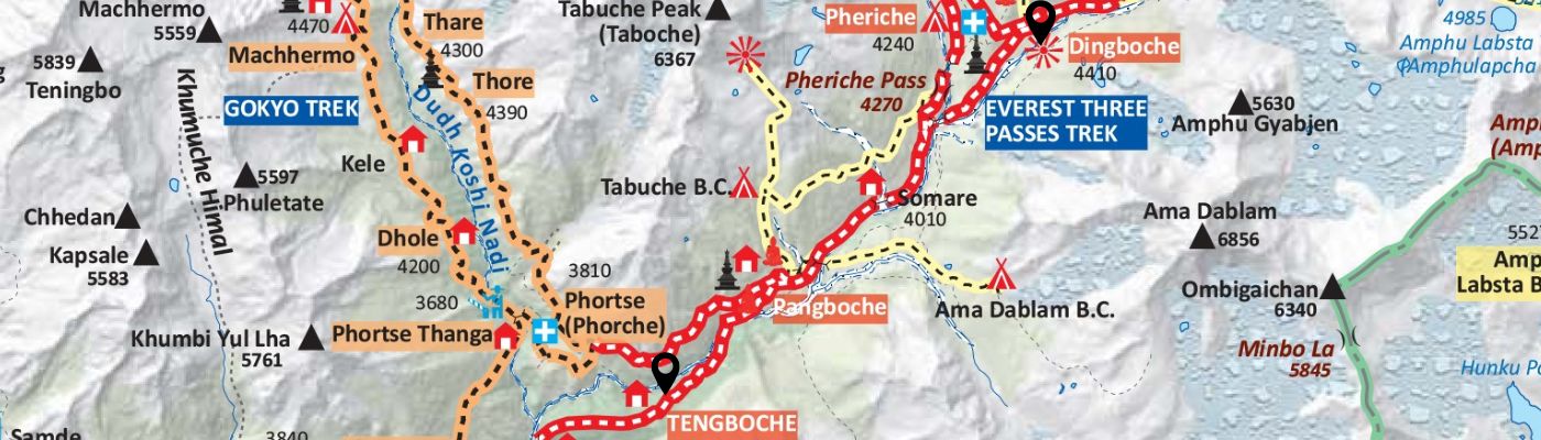
Tengboche to Dingboche outline map
The trek from Tengboche to Dingboche (4410m) marks a crucial transition into the high-altitude alpine zone, with a net gain of over 500 meters. The main EBC trail (red line) descends from Tengboche and follows the valley floor, passing through the villages of Pangboche (Phorche) at 3810m, and continuing upstream to Somare (4010m). From there, the path splits, with one fork leading to Pheriche (4240m) and the other taking a direct route to the day's destination, Dingboche (4410m).
This stage is defined by the presence of major alternative treks and peaks. The Gokyo Lake route branches off to the west, tracing the Dudh Koshi Nadi past settlements like Phortse Thanga (3680m), Dhole (4200m), Thore (4390m), Thare (4300m), and Machhermo (4470m).
Furthermore, the challenging Everest Three Passes Trek is indicated on the map, running near Pheriche and over the Pheriche Pass (4270m). The views are spectacular, dominated by peaks such as Tabuche Peak (Taboche) (6367m) and its Base Camp, and the magnificent pyramid of Ama Dablam (6856m), along with its base camp (Ama Dablam B.C.).
Dingboche to Lobuche Map with Distance and Duration
Dingboche to Nagarjun Hill (and return) | Distance: 5–6km / 3–3.7 miles | Duration: 4–5 hours | Height Gain: +690m
Dingboche to Lobuche | Distance: 11–12km / 6.8–7.5 miles | Duration: about 5 hours | Height Gain: +500m
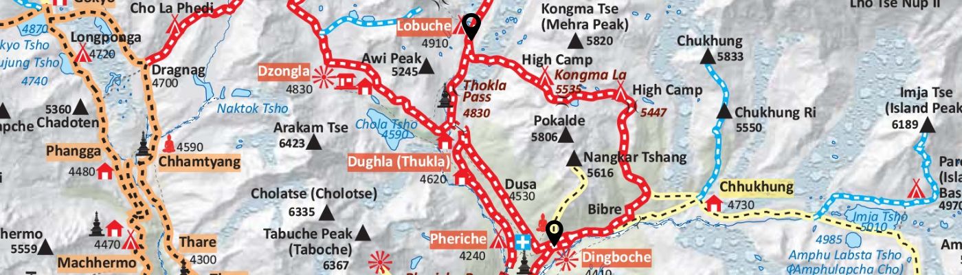
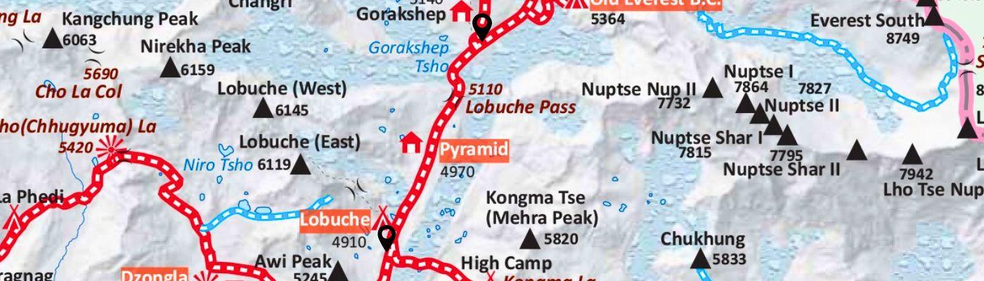
The standard Everest Base Camp route map from Dingboche (4410m) to Lobuche (4910m) is characterized by a steady gain in elevation as the trail moves deep into the high Khumbu valley.
The trek proceeds through the flat valley floor from Dingboche past a settlement named Dusa (4530m). The most demanding section of the day is the steep climb up to the village of Dughla (Thukla) (4620m), which is positioned at the base of the terminal moraine. After Dughla, the path ascends the moraine, crossing the Thokla Pass (4830m), a high point that features a series of memorials for climbers and Sherpas. Finally, the trail flattens out, following the glacier edge to reach the overnight destination of Lobuche (4910m).
Note on Alternate Routes:
The map also clearly displays the route for the Everest Three Passes Trek continuing to the west toward Dzongla (4830m) and Dragnag (4700m) after Dughla. The eastern route shows the path leading to Chhukhung (4730m) and Chhukhung Ri (5550m), an important acclimatization side trip leading toward Imja Tse (Island Peak) (6189m).
The village of Dingboche (4410m) is the starting point for a significant acclimatization hike up the slopes immediately to the north. The trail ascends to Nangkartshang (5,616 m); however, trekkers only reach a height of 5,100m, which is marked on the map as a high point directly above the main valley. This strenuous climb is located in the shadow of Pokalde (5806m) and offers elevated views of the Imja Valley and the surrounding peaks.
Lobuche to Gorakshep Outline Map
Lobuche to Gorakshep | Distance: 4–5km / 2.5–3.1 miles | Duration: 2–3 hours | Height Gain: +270m
The segment from Lobuche (4910m) to Gorakshep (5164m) is the final trekking stage before reaching Everest Base Camp. The trail maintains a high altitude, running parallel to the vast Khumbu Glacier. The route begins at Lobuche and follows the moraine, with a gradual but challenging incline due to the extreme elevation. The path crosses rough, rocky moraine terrain before reaching Gorakshep (5164m), which is situated on a frozen lakebed and serves as the last settlement with teahouses.
Gorakshep to EBC and Then to KalaPathhar
Gorakshep to Everest Base Camp and back | Distance: 8–9km / 5–5.6 miles | Duration: 4–5 hours | Height Gain: +184m
Gorakshep to Kala Patthar and back | Distance: 3–4km / 1.8–2.5 miles | Duration: 2–3 hours | Height Gain: +365m
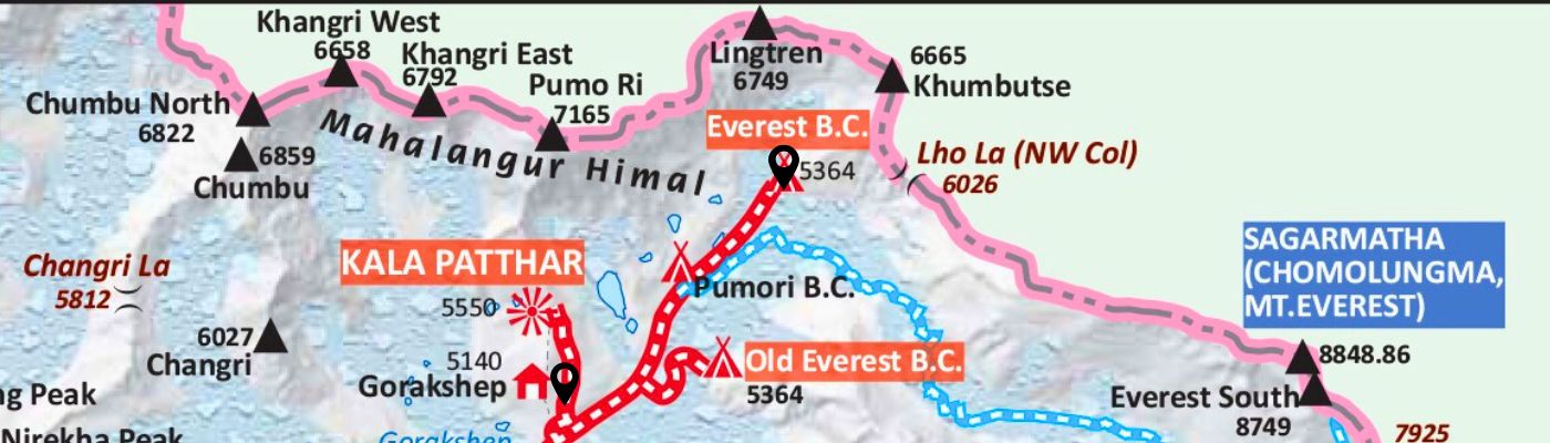
The high-altitude settlement of Gorakshep (5140m) serves as the critical base for the final objectives of the EBC trek, both situated within the Mahalangur Himal range. The final trekking route follows the glacial moraine toward the base of the Everest massif. The ultimate goal for trekkers is the Everest Base Camp. (5364m), positioned below the prominent Lho La (NW Col) (6026m), with the former location, the Old Everest B.C., also marked at the same elevation.
The Everest peak itself, designated as SAGARMATHA (CHOMOLUNGMA, MT. EVEREST), reaches an elevation of 8848.86m. Additionally, the challenging climb to the viewpoint of Kala Patthar (5550m) is undertaken from Gorakshep, rewarding climbers with iconic views of Everest and the surrounding peaks. The panoramic setting is defined by towering neighboring mountains, including Pumo Ri (7165m), Lingtren (6749m), and Khumbutse (6665m).
Gorakshep to Pheriche Map
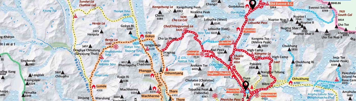
The return trek from the highest overnight point on the EBC route, Gorakshep (5140m), back down to Pheriche (4240m) involves retracing the demanding high-altitude path through the Khumbu Valley.
The route then continues south down the Imja Khola Valley to the final destination for the day, Pheriche (4240m), a village located near the junction where the Everest Three Passes Trek route to Kongma La Pass (5535m) begins.
Pheriche to Namche Bazaar Map
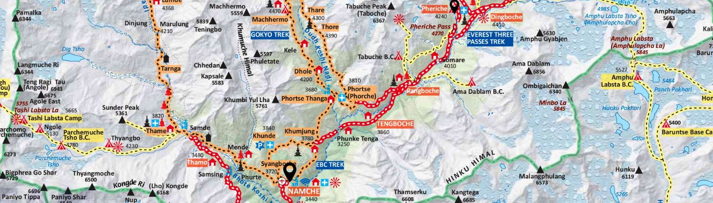
The descent on the EBC standard route from Pheriche (4240m) to Namche Bazaar (3440m) involves retracing the trail through the high valley, initially passing Tengboche (3860m) and its steep drop to Phunke Tenga (3250m) before climbing back up to the contour trail leading to Namche.
Namche Bazar to Lukla Distance, Duration and Map
The return journey from Namche Bazaar (3440m) to Lukla (2840m) involves a multi-stage descent along the Bhothe Koshi Nadi valley. The route drops from Namche through Phakding (2610m) and then involves a final short climb through villages like Chheplung (2660m) to reach the end point at the Lukla airport.
Street map view of Everest Base Camp, Google Maps
Using Google Maps Offline on the Everest Base Camp Trek (2025 Update)
Yes, you can use Google Maps offline for the Everest Base Camp Trek, but it should only serve as a secondary navigation tool. The Himalayas are remote and unpredictable, and while Google Maps can help you locate yourself, it lacks the detail needed for safe trekking in high-altitude terrain.
Everest Base Camp Trek Map Google Maps
Checkout our Popular Everest Base Camp Trek packages with the Map and itinerary
Short Everest Base Camp Trek 14 days Map and Itinerary pdf download available
Everest Base Camp Trek Package PDF with map and itinerary in detail
Mount Everest Trek with Gokyo and Renjo La pass Map
Everest Base Camp Trek with High Passes Map and Itinerary in detail
Everest Panorama Trek Map and Itinerary
Everest Map: The Everest Experience with Nepal Hiking Team
You can download Google Maps or use it offline like Google Map, Maps.me, Organic Maps, Avenza, a hand map or Gaia GPS to help you follow the Everest Base Camp route. These tools and paper are great for navigation, but a screen can only tell you so much. The map shows lines and dots and lines to the villages, yet it doesn’t reveal the life, weather, challenges, myths, struggles of Sherpas and stories behind them.
When you’re ready to take that step from the digital line on a map to the real path underfoot, Nepal Hiking Team is here to make it effortless. From the day you land to Kathmandu until you reach the Everest Base Camp and finally to departure we are here with you as a Guide and Family.
So, if you’re ready for the real journey, looking for a lifetime experience to Mount Everest, we the Nepal Hiking Team are ready too. With nearly two decades of field experience in the Everest region, we help you experience this legendary trail with confidence and wonder.
For any confusion about routes, itineraries, customisation or Everest Base Camp trek details, feel free to reach out to us. Book your EBC Trek 2025/26 package with Nepal Hiking Team.
Post a Comment