
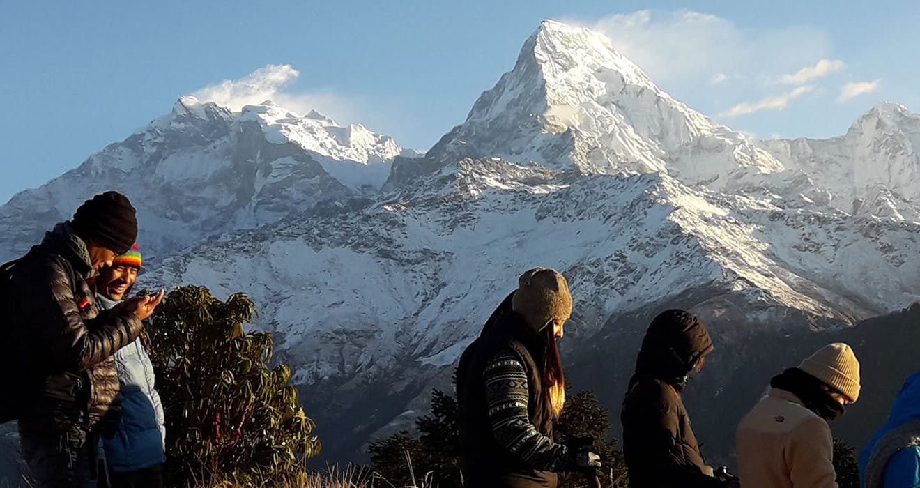
Nepal, albeit being a relatively small country, certainly does not lack trekking destinations. Nepal is a multi-ethnic, multi-lingual, and multi-cultural nation. It consists of diversity in all aspects, from its natural topography, biodiversity, people, and ethnicity, and tradition. Consisting of fantastic Himalayan ranges to its north and many exotic cultural villages and settlements, Nepal is famous worldwide for its trekking experiences. Some renowned trekking regions in the country include the Everest Region, the Annapurna Region, Langtang, the Manaslu region, and the Mustang, among many others. Among all of them, the Trekking in Annapurna Region is perhaps one of the most famous ones.
Its popularity is well-deserved as the region's various feature of beautiful natural scenery, and hill culture is not found anywhere else. About two-thirds of the trekkers visiting Nepal tend to trek in the Annapurna Region. Its appeal is primarily based on its easy accessibility, great guesthouses, lodges in the mountains, fantastic mountain landscape, and ethnic prominence.
Trekking in the Annapurna Region often starts close to or from Pokhara, a relaxing place to end a trek and a comfortable place to create one. With amazing close-up views of the mountains just a day up the trail, trekking in the Annapurna region is particularly feasible with good communications and safety. Sustainable tourism in the Annapurna region is mainly thanks to the ACAP- the Annapurna Conservation Area Project.
Launched in 1986, ACAP is the most considerable undertaking of NTNC (Nepal Trust for Nature Conservation) and is also the first conserved area and the largest protected area in Nepal. Covering an area of 7,629 square kilometers, the ACAP is home to over 1000,000 residents of different cultural and linguistic groups, along with a treasure trove of biodiversity and natural elements. The natural and cultural features of the Annapurna region have made it the most popular trekking destination in the country. Annapurna draws in more than 60% of the country's total trekkers annually.
Over the years, tourism has managed to be firmly established as one of the most critical and fast-developing sectors of the local economy. With over a thousand tea-houses, lodges, guesthouses, and hundreds of other subsidiary services caterings to tourism, the Annapurna region has managed to become internationally well-known, both for its formidable mountain peaks and its natural beauty. Popular treks in this region are on well-beaten tracks, along with a few off-the-beaten-track destinations as well. It is a perfect combination of natural delights and cultural tenor.
Topography and Climate of the Annapurna region
Located in west-central Nepal, the Annapurna region stretches from sub-tropical lowlands with lush temperate rhododendron forests in the south to dry alpine steppe environments in the north. The area also supports dense coniferous forests containing several orchids and many of Nepal's 700 medicinal plants. The region's physical features are dominated by mountain ranges and Himalayan peaks of the Annapurna massif, the Nilgiri Himal, the Tilicho Peak, Himchuli Himal Machhapuchhre, Gangapurna, Lamjung Himal, the Tukuche Peak, and many more. The Annapurna Mountain range stretches from the north to the south of the region, and the Kali Gandaki and the Marshyangdi Rivers lie on either side.
Three major river systems also drain the Annapurna Conservation Area. The region's altitudinal range varies drastically from 1,000 meters above sea level to 8,000 meters, resulting in a mosaic of different geographical zones, from subtropical conditions in the south to alpine zones in the north. In a stretch of fewer than 50 kilometers, the terrain consists of tropical hardwood trees, pine-clad hills, oak woodlands at medium altitudes, and rhododendron and fir forests giving way to birch and juniper hamlets before the terrain finally changing to alpine scrublands, grasslands, meadows, and treeless zones the higher up the elevation goes. The region can be broadly divided into two distinct ecological settings: the Trans-Himalayan and cis-Himalayan.
The Trans-Himalayan part of the Annapurna includes the Upper Kali Gandaki and the Upper Marshyangdi Valleys. In contrast, the cis-Himalayan region comprises the valleys of Madi, Bhujung, lower Kali Gandaki, and Lower Marshyangdi.
The Climate also varies with altitude and aspect. There are a 6°C drop in the temperature for every 1,000 meters rise in elevation. The average daily temperature decreases between December and February (the winter season) and reaches a maximum between May and July (the summer). The monsoons dominate the seasonal climate between June and September, and the rainfall type is also closely related to altitudes and rain-shadow effects. The best seasons for visiting the Annapurna region for trekking would be the spring season and the autumn. The spring lasts from March to May, and autumn affects the part from September to December.
Annapurna Region Wildlife
The cultural diversity of the region is equally rivaled by its unique and notable wildlife as well. The variation in altitude and topography and the existing forest cover provide a wide range of habitats to many animal species. There are a recorded 1,226 species of flowering plants, 102 species of mammals, 474 birds, 39 species of reptiles, and 22 species of amphibians found in the Annapurna Conservation Area.
Exotic and elusive animals like the Himalayan black bear, Himalayan Thars, the barking deer, Ghorals, the blue sheep, Musk deer, Red Pandas, and Snow leopards occupy the woodlands. All of these listed animals are endangered. The Annapurna region also provides excellent habitats for a wide variety of spring and autumn birds migrating from India, China, and other areas.
Furthermore, many other animals have a home in the forests, and trekking along the lush acreages of vegetation may result in encountering them. Some common animals, as opposed to the more elusive ones mentioned before, includes the Pika. It is not a rare disorder, but it is a tiny fluffy ball of a mammal with short limbs, rounded ears, and no external tail. These little critters are commonly spotted on the famous Annapurna Circuit, and they resemble slightly smaller versions of chinchillas. And although the Abominable Snowman (the Yeti) sounds like a fabricated tale given its lack of conclusive evidence, they are not entirely off the grid as many locals believe that they have caught a glimpse of this giant in the Himalayas.
The Ethnic Diversity of the Annapurna Region
The cultural diversity of the region consists of people of Gurung and Magar ancestry. In the south, Gurung and Magar ethnic groups dominate, whereas Thakali, Manange, and Loba people overlook in the north. Each of these groups speaks its dialect and has its own unique cultures and traditions. Brahmin, Chhetri, Kami, and Newar ethnicities and other occupational casts also occur in comparatively smaller groups in the peripheral parts of the region. There is a significant prevalence of Hindu and Buddhist religions in Annapurna.
The settlement pattern is mostly clumped in most Gurung villages, whereas the settlements tend to be more scattered at other ethnic villages. This heterogeneous culture of the region attracts a large number of tourists. Speaking in precise terms, the people who occupy the high mountain regions are the Gurungs, Thakalis, and the Bhotias, as other minor groups occupy the lowlands.
As with many other rural areas of Nepal, the people in the Annapurna region depend on traditional agricultural practices and farming for their livelihood, along with tourism and animal husbandry. Buffalo and cattle-rearing occur all over the area, and they are utilized for milk and dairy production, drafting, and other purposes. Yaks are also reared at villages lying above 2,000 meters, along with sheep and goats. It is common to come across herds of domesticated cattle heading off to pastures while trekking in the Annapurna region.
Most people are also involved in other socio-economic activities like porters, operating tea shops and lodges, producing and selling handicrafts, and collecting medicinal plants. The dependence of the local people on natural resources is also abundantly seen in many activities.
While trekking in the Annapurna, the opportunity to observe many unique traditions of the ethnic people becomes an experience that fascinates travelers. For example, one exciting custom followed by the Gurung people, called bandhane, takes place three days after the birth of a baby. This customs entails wrapping the newborn baby in a long piece of cloth after the baby has been washed in cow's milk. Other region customs include the Magar ladies adorning themselves in traditional Magar attire with complete (flower-like ornaments) in the middle parts of their ears and necklaces made of glass beads and coins. Likewise, other ethnic groups also showcase their mastery of traditional costumes, folk dance, and folk songs during celebrations and festivities.
Highlights of the Annapurna region
Pokhara
Pokhara is perhaps one of the most famous cities of Nepal and the starting point of most of the trekking journeys of the Annapurna region. The metropolis of Pokhara is the largest city of Nepal in terms of area and is located west of Kathmandu. Its altitude varies from 837 meters in its southern part to 1,740 meters in the north. The Annapurna range has three of the ten highest mountains globally- Dhaulagiri, Annapurna I, and Manaslu- lie 15 to 35 miles away from the Pokhara valley. Also referred to as the "Tourism Capital of Nepal" and "the country's adventure hub," Pokhara has various lakes, caves, extreme sports, and museums that pull in crowds from all over.
The city of Pokhara lies at the northwestern corner of the valley and has the Seti Gandaki River draining through it. The Seti Gandaki, which translates to "the White River," has created many tributaries in the city, along with several gorges and canyons in and around Pokhara that intriguingly gives the city long sections of terrace features. Pokhara also borders the Phewa Lake in the south, a part that earned its name as "the Lake-side City." The Himal of Machhapuchhre also lies close, and its reflection can sometimes be seen on Phewa Lake's tranquil waters. Several caves can also be found within the city's limits. In the south of the city, a tributary of the Seti mentioned above, Gandaki flowing out of the Phewa Lake disappears at Patale Chhango- The Davis Fall (named after someone who supposedly fell in).
The waterfall plunges through rock formations and into an underground gorge and reappears about 500 meters further south. The Begnas Lake also lies to the city's southeast, and many other lakes dot the area, like Rupa Lake, Khaste Lake, Maidi Lake, Neureni Lake, and Dipang Lake.
Pokhara also has many temples and Gompas scattered throughout its parameters, and many pertain to both the Hindu and the Buddhist people. The Tal Barahi Temple lies on an island in the middle of Phewa Lake. Likewise, other notable places of worship include the Bindabasini Temple, the Gupteshwor Mahadev Cave/Temple, the Sunpadeli Keseri, and the World Peace Pagoda, among many others.
Tilicho Lake
Tilicho Lake is the highest located lake globally, and it is situated 55 kilometers away from Pokhara. It is also considered one of the largest in the country. The Lake of Tilicho has many mountains surrounding it, like the Khangsar Himal, the Muktinath peak, and the Tilicho Himal. The turquoise waters of the Tilicho Lake are pretty mesmerizing, and the lake is a famous side-hike among trekkers doing the Annapurna Circuit.
The lake is a source of the glacial melt of the entire northern slope of the Annapurna and the Thorung Peak. The lake was also the site where hundreds of Hindu pilgrims flocked to after being convinced that the lake was mentioned in the Hindu epic- Ramayana. Its tranquil atmosphere and the serene, undisturbed water make for a fascinating destination for trekkers. The lake is often used as a respite after a long day's trek.
Annapurna Base Camp
The Annapurna Base Camp is a famous trekking destination of the Annapurna region. Reaching the base camp of Annapurna is a trekking journey that trekkers from all over the world do. The trip to the base camp consists of regular trekking routes that pass through the region's villages and terrains. It is a prominent trekking experience in Nepal and the region's most famous trekking journey.
Starting from the city of Pokhara, the Annapurna Base Camp Trek consists of the western portions of the Annapurna Himal range, making appearances along the trip in a very prolific and spectacular fashion. Comprising of Hiunchuli, the Annapurna South, Fang, Gangapurna, Annapurna III, and the Machhapuchhre Himal, the western face of the Annapurna massif is arranged in a precise form that creates a bend having a diameter of almost 10 miles. This resembles a natural Himalayan amphitheater, where trekkers travel along steppes of beautiful forests and cultural villages.
Poon Hill
Poon Hill is a famous vantage point of the Annapurna region that offers a spectacular panoramic view of the entire Annapurna mountain massif. It is visited by many trekkers and is quite a popular destination in the area. Because of its panoramic view, trekkers tend to get back early in the dawn and hike to Poon Hill from Ghorepani to look at the breathtaking phenomenon of the rising sun amidst the Annapurna mountains.
The changing colors of the cerulean mountains as the rays of the sun sweep across their surface are pretty beguiling. Poon Hill is also part of the Annapurna Base Camp Trek, and the wide-open expanse of the vantage point with the sight of the mountains right in the front is one of the most impressive aspects of the region. It is reached by hiking from Ghorepani- a small village that occurs along the base camp trail. Coincidentally, Ghorepani also has one of the most extensive rhododendron forests in all of Nepal.
The Kali Gandaki Gorge
The deepest canyon in the world, the Kali Gandaki Gorge, also called Andha Galchi, marks a prominent presence in the Annapurna region. The gorge separates the significant peaks of Dhaulagiri on the west and the Annapurna I on the east, with a portion of the Kali Gandaki River flowing directly between the two mountains. The upper part of the gorge is also called the Thak Khola, named after the local Thakali people.
Kali Gandaki Gorge has been used as a trade route between India and Tibet for centuries. Today, it is a popular part of the famous Annapurna Circuit Trek. The gorge also lies within the Annapurna Conservation Area and is named after the Hindu goddess Kali. The exact depth of the canyon is still debated, but it is estimated to be about 6,000 meters deep. Surrounded by majestic mountains, the gorge is visited by many pilgrims and travelers.
The Kali Gandaki River
The river is a primary drainage system of the Annapurna region, with its source at the border of Tibet. It originates from the Nhubiene Glacier Himal in Mustang and flows southwest through the Kali Gandaki Canyon. The Kali Gandaki River is older than the Himalayas and is known for containing Saligram fossils. These Saligrams are considered holy by the Hindu people, and they are believed to be the non-living forms of Lord Vishnu. After flowing through the gorge, the river turns east and runs along the northern ridge of the Mahabharata range.
Muktinath
Muktinath is a famous sacred place that pertains to both the Hindu and the Buddhist people. The temple of Muktinath is located at the foot of the Thorung la Pass, and it is a popular destination that occurs during the Annapurna Circuit Trek. Muktinath is often called "a place of liberation" and is considered a highly revered place of religious significance. It is one of the most ancient temples dedicated to Lord Vishnu and is one of the 51 Shakti Pitha Goddess Site.
The small temple contains a human-sized golden statue of Lord Vishnu and bronze images of Bhoodevi- the Earth-Goddess form of Lakshmi. The temple also has pictures of Lava-Kusa, the sons of Lord Ram, and the princess Sita. For Tibetan Buddhists, Muktinath is considered an important place for Dakinis, goddesses known as Sky Dancers, and the temple is one of the 24 Tantric places. There is a semi-circular wall behind the temple that has 108 stone faucets with heads carved into bulls. The ice-cold water of the Kali Gandaki River flows through these faucets, and pilgrims often stand beneath each sprout.
The Thorung La Pass
The Thorung La is a famous mountain pass that has an elevation of 5,416 meters. The key lies north of the Annapurna Himal and is located on the trail which connects the village of Manang in the east with the temple of Muktinath. The Thorung La is also the highest point on the Annapurna Circuit Trek, and the local people use the mountain pass for trade. The mountain pass is generally devoid of vegetation and has a dry environment. Because of its strategic location of being shielded by the monsoon rains by the Annapurna Himal, the Thorung La Pass, along with the Manang Valley, receives significantly less precipitation. Strong winds sweep across the pass, and sometimes, heavy snow accumulates during the winter.
The Annapurna Sanctuary
The Annapurna Sanctuary is a huge part of the Annapurna Conservation Area. It is a high glacial basin that lies 40 kilometers directly north of Pokhara. The topography of the sanctuary resembles an oval-shaped plateau that sits at an altitude of 4,000 meters. Surrounded by a ring of the Annapurna Mountains, the entrance to the monastery is located at the narrow valley between the Hiunchuli and the Machhapuchhre peaks. Because of the high mountains on all sides, the Annapurna Sanctuary receives only 7 hours of sunlight a day at the height of summer.
The unique combination of size and depth of the sanctuary gives rise to various ecosystems, with rhododendron and bamboos flourishing towards its southern slope and a dry arid landscape resembling the Tibetan plateau towards the north. The entire sanctuary is sacred by the Gurung people, and they believe that the area was a repository of gold and various treasures left by the Nagas- the serpent gods.
Tatopani or Hot Spring
"Tatopani" literally translates to "Hot Water"- a befitting name for its natural Hot Spring. The bubbling water of the hot spring sits in a sizeable serene rock pool at Tatopani, and it is a semblance of a Japanese-style spring of hot water. The naturally occurring hot spring at Tatopani is believed to cure ailments of the body by the local people and is said to have medicinal properties.
Tatopani lies about 5 kilometers away from Kodari, on the border of Nepal and Tibet. The hot spring's waters are coveted for having high mineral content, and they stand out as natural healing elements. The relaxing water of the hot spring tends to rehabilitate the muscle and offers a rejuvenating interlude during long hikes and trekking journeys. The hot spring temperature at Tatopani borders on mild to moderate, and the spring releases amounts at various points around the hot spring compound.
Ghandruk Village- The Switzerland of Nepal
Ghandruk is a popular place for treks in the Annapurna region. The views of the Annapurna Mountains from the village of Ghandruk, as well as the sight of the Machhapuchhre Himal and the Hiunchuli peak, are utterly marvelous. The town is located at about 4 to 5 hours walking distance away from Pokhara and is inhabited by Gurung people. Situated at an altitude of 2,012 meters, Ghandruk offers traditional and rural features. The village's location on the mountainside with the Himalayas decorating the sky's tapestry provides a picturesque sight that looks like it has been painted on a vast green canvas. Ghandruk is also considered the central hub of the ACAP, where the local people, donkeys, and mules are seen trudging along the village's cobbled-lines street.
Marpha Village
The village of Marpha is another famous village of the Annapurna region. Its terminology comes from a combination of two words- "mar," which means "Hard Working," and "Pha," which means "People." With tourism and mule rearing serving as the primary livelihood of the people, the village of Marpha is also referred to as "the apple capital of the nation." Local Marpha brandy, apple pies, and apple jams produced in the village are considered some of Nepal's most exotic and delicious delicacies. A pretty stone-lined village, Marpha has managed to survive in the current time by catering to tourism.
Dominating the village is the Nyingma monastery, from which there are good views of the village and the Gandaki River valley. Above the monastery lies a chorten painted onto the cliff face, with several small stone chortens on the ledges below. Legend says that the villagers became afflicted with leprosy, and all attempts to control it had failed. Initially from Tukuche, south of Marpha, a local monk advised the villagers to build the chorten and hold religious rituals at the site. Since then, leprosy stopped, and Marpha flourished once more. On the opposite bank of the Gandaki River on the southern outskirts of Marpha lies a Tibetan refugee camp and the Chhairo Gompa, the first Nyingma monastery to be established in the district of Mustang.
The Annapurna Region offers many more highlights. Trekking in Annapurna Region is one of the most dramatic and beautiful experiences in Nepal. It is a great way to get into Nepal's diverse beauty and many authentic cultures, history, religion, and features.
Post a Comment