

Mount Makalu sits in the eastern Mahalangur Himalayas, on the border between Nepal and China. It’s in the Sankhuwasabha District, inside Makalu Barun National Park in Nepal. On the Chinese side, it is in the Tibet Autonomous Region. As the world’s fifth highest mountain, Mount Makalu stands at an elevation of 8,485 meters (27,838 feet). The mountain has a unique four sided pyramid shape and sits 19 km southeast of Mount Everest.
The guide covers Mount Makalu’s location, height, rank, routes, and fun facts. It covers the history of climbing, popular treks, and tips for planning the Makalu wilderness journey.
Mount Makalu: The Fifth Highest Mountain in the world
Rising to 8,463 meters (27,838 feet), Mount Makalu is the fifth highest mountain in the world. It is part of the Mahalangur Himalayas, a subrange of the Himalayas. The location sits about 19 kilometres southeast of Mount Everest, making it one of the most famous mountain landscapes in the world.
| Detail | Value | |
| Coordinates | 27° 53' 23'' N, 87° 05' 20'' E | |
| Elevation | 8,463 meters (27,838 feet) above sea level | |
| Country Border | Nepal | (South/West) |
| China | (North/East) | |
| Protected Areas | Nepal | Makalu Barun National Park |
| China | Qomolangma National Nature Preserve | |
Which country is Mount Makalu in?
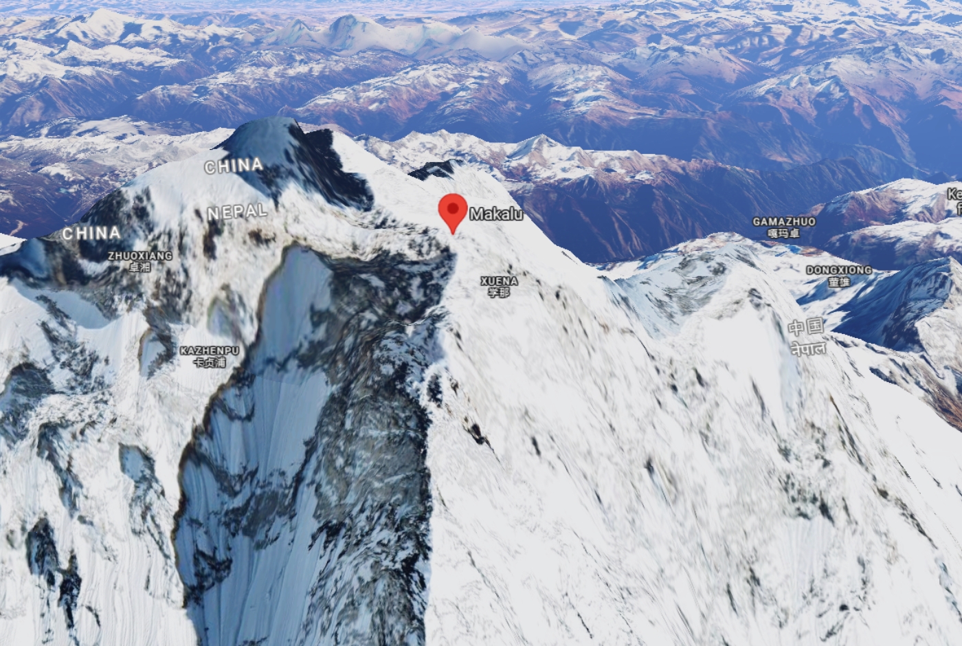
Mount Makalu is right on the border separating Nepal from China. The mountain peak splits into two main sections. The southern half is in Nepal’s eastern Sankhuwasabha District. The northern half extends from Tibet.
Most climbers and trekkers approach Makalu from Nepal, where access routes and expedition logistics are more established. That is why Nepal is often the side most associated with the mountain in travel writing.
| Country | Details | |
| Nepal | Province | Koshi Province |
| District | Sankhuwasabha District | |
| Municipality | Makalu Rural Municipality. | |
| China | Autonomous region | Tibet Autonomous Region |
| Prefecture | Shigatse City | |
| County | Tingri County | |
Mount Makalu’s Height and Ranking
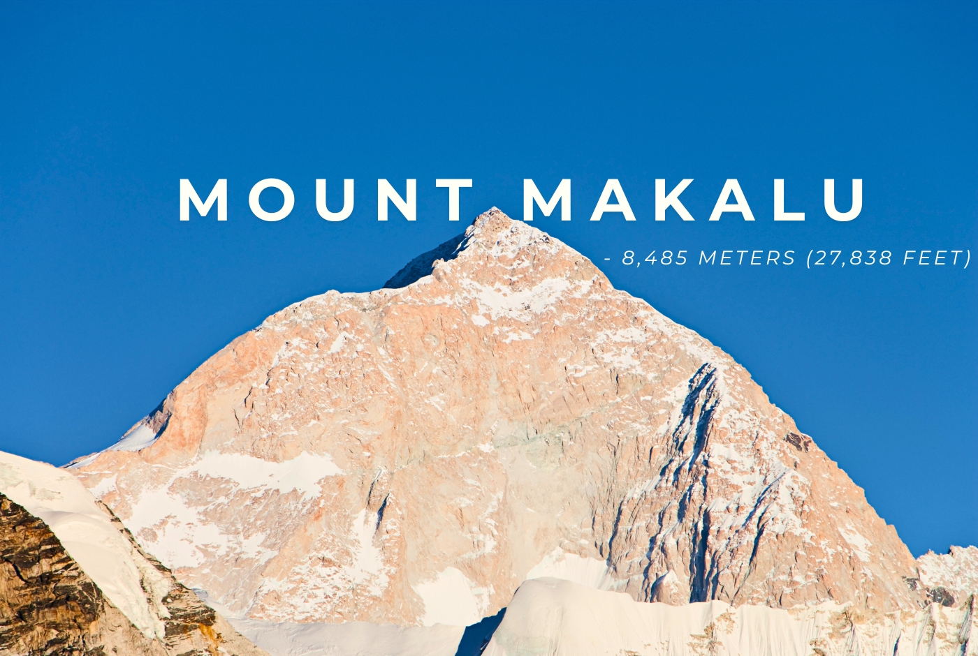
Mount Makalu is the fifth highest mountain in the world. Its height is 8,463 meters (27,838 feet) above sea level. Only Mount Everest, K2, Kangchenjunga, and Lhotse are higher.
Makalu may not be the tallest mountain, but it is one of the most prestigious peaks in the Himalayas. Its height, shape, and isolation make it stand out among the world’s highest mountains.
| Detail | Value |
| Global Rank | 5th highest mountain in the world |
| Nepal Rank | 4th highest mountain in Nepal |
| Official Height (Meters) | 8,463 meters |
| Official Height (Feet) | 27,838 feet |
| Prominence | 2,386 meters (7,828 feet) |
| Isolation | 19 kilometers (12 miles) from Mount Everest |
Which mountain range is Mount Makalu part of?
Mount Makalu is part of the Mahalangur Himalayas, a key subrange of the Himalayas. This mountain range lies along the border of Nepal and Tibet. It features famous peaks like Mount Everest, Lhotse, and Cho Oyu. Therefore, Makalu is part of a region known for the highest mountains on the planet.
Mount Makalu stands at 8,463 meters, making it the fifth tallest mountain in the world. Its spot in the Mahalangur Himalayas makes it important for geography and mountaineering.
Where is Mount Makalu located on a map?
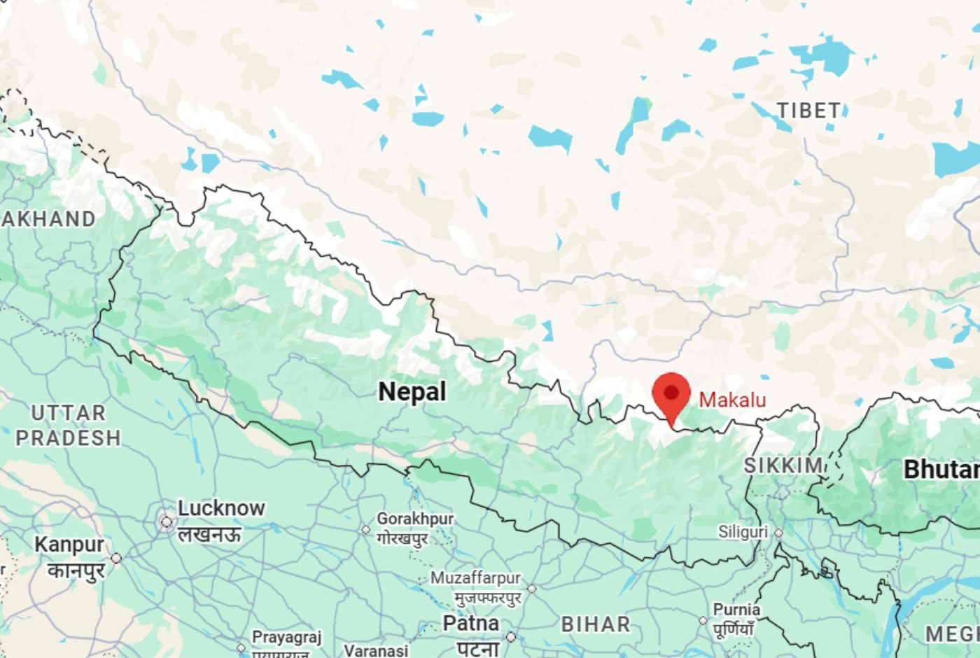
Mount Makalu lies about 19 kilometers southeast of Mount Everest. Nearby peaks include Kangchungtse, or Makalu II, to the northwest, and Chomo Lonzo to the northeast. Other mountains connected to the broader region include Baruntse and Chamlang.
One of the regions around Mount Makalu is the Barun Valley. This glacial valley features stunning cliffs, beautiful waterfalls, green forests, and untamed nature. The scenery changes fast from green lower slopes to snowy high mountains and alpine land which makes the region especially memorable for both travelers and climbers.
How to reach Mount Makalu from Nepal and Tibet?
To get to Mount Makalu, you can choose between two main routes: one from Nepal and another from China. However, the most common and explored route is through Nepal.
Route from Nepal to Mount Makalu
The trekking route begins at Tumlingtar, which can be reached by taking a flight from Kathmandu. From there, the actual walking path starts at Num (1,560m. Then, the trail moves to Tashigaon (2,100m), which serves as the very last inhabited village where people live along the route.
As the incline sharpens up a very steep hill, you reach Khongma Danda (3,500m). Continuing upward, the trek crosses the Shipton La Pass (4,200m). The path then drops into a quiet valley at Yangle Kharka (3,557m), which is a flat, grassy area.
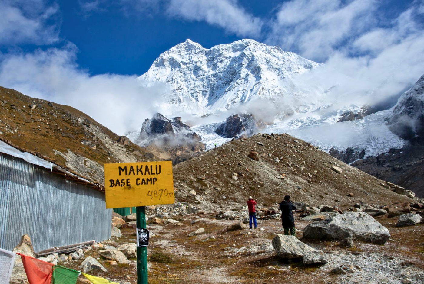
For trekkers, the final stop is Makalu Base Camp (MBC) at 4,870m, a sandy environment located close to the glacier river.
For mountaineers pushing onward to the summit, the journey transitions to the rocky and icy Advanced Base Camp (ABC) at 5,700m. From ABC, climbers navigate the high-altitude challenges of Camp 1 to Camp 4 (6,200m – 7,600m).
Finally, after overcoming these technical segments, climbers reach the Makalu Summit at 8,485m, the very top of the mountain composed entirely of sharp ice and exposed rock.
Planning a trip to such a remote region involves complex logistics from permits to safe, high altitude accommodation. To ensure a secure experience, the Nepal Hiking Team provides a comprehensive 19-day itinerary. This all-inclusive journey manages your entire trip from arrival in Kathmandu to final departure, allowing you to focus entirely on the trip ahead.
Route from China to Mount Makalu
The trekking and climbing route from the China (Tibet) side begins in the major cities of Lhasa and Shigatse (3,650m to 3,840m), where travelers typically arrive by plane or train.
From there, the journey moves by vehicle to Tingri and the Kharta Valley (4,300m), marking the point where cars can go no further and yaks are used to carry the expedition's bags.
Leaving the valley floor, trekkers ascend through the Shao La Pass (4,700m to 4,900m), navigating high paths covered in loose rocks that eventually lead down into the stunning Kama Valley (4,500m). The trail then pushes upward to reach Makalu North Base Camp at 5,000m, establishing a rocky campsite situated directly at the bottom of the mountain’s giant North Wall.
For mountaineers pushing onward to the summit, the route requires ascending to the Makalu-La at 7,400m, which is a very high snow ridge connecting two mountain peaks.
Finally, after tackling the demanding upper altitude, climbers arrive at the Makalu Summit at 8,485m.
Why is Nepal the popular route?
Nepal's route is popular because it provides a much more accessible and technically safe ascent via the standard Northwest Ridge than the sheer, hostile faces on the Tibetan side.
Furthermore, Nepal has a well-developed mountaineering infrastructure, including seasoned Sherpa guides, dependable porter networks, and established base camps that simplify complex expedition logistics.
Lastly, it is the choice for almost all commercial and independent climbers due to the simple permitting process and the natural, gradual acclimatisation trek through the stunning Barun Valley.
Comparison between Nepal and China Route of Mount Makalu
| Feature | Nepal Approach (South) | Tibet Approach (North) |
| Primary Base Camp | 4,870 meters (Barun Valley) | 5,000 meters (Kama Valley / North base) |
| Terrain Style | Deep river valleys, dense rainforests, steep steps | Arid high altitude plateau, wide alpine valleys |
| Infrastructure | Basic local teahouses & lodges | Mostly fully supported wilderness camping |
| Physical Toll | High due to massive daily ups and downs | High due to rapid vehicle-based altitude gain |
| Regulatory Authority | Department of Tourism (Nepal) | China Tibet Mountaineering Association (CTMA) |
Why is Mount Makalu famous?
Mount Makalu is famous for its dramatic four-sided pyramid shape and its extreme climbing difficulty. It is also well known for being part of the beautiful and biodiverse Makalu-Barun region.
Mount Makalu’s location near Everest gives it recognition, but its isolation gives it a character of its own. Unlike Everest, Makalu is not crowded with tourists and commercial traffic. It still feels wild, remote, and adventurous, which adds to its appeal.
Mount Makalu was first successfully climbed on May 15, 1955, by a French expedition led by Jean Franco, and that historic ascent added to its legacy.
Today, Makalu is remembered as one of the great challenges of Himalayan mountaineering.
Interesting Facts about Mount Makalu
Mount Makalu is relatively unexplored and not commercially popular due to the difficult terrain. However, there is an increasing trend of tourists searching for safer ways to explore the mountain and its surrounding areas. Here are some of the interesting facts about Mount Makalu.
- The Great Black Pyramid: Makalu gets its name from the Sanskrit word Maha Kala, meaning "Big Black". This perfectly describes its iconic, exposed, four sided pyramid structure that does not retain snow easily due to wind.
- The World’s Fifth Highest: Towering at 8,463 meters (27,838 feet) above sea level, it sits firmly as the fifth highest mountain on Earth, trailing only Everest, K2, Kangchenjunga, and Lhotse.
- A Truly Geographical Isolated Giant: Even though it sits just 19 kilometers (12 miles) southeast of Mount Everest, its massive prominence of 2,386 meters means it is an entirely independent mountain system, not a sub peak.
- The Dreaded Kangchungtse (Makalu II), 7,678m: Makalu has a notable twin satellite peak named Kangchungtse (or Makalu II) at 7,678 meters. It is connected to the main peak by a massive, high altitude saddle known as the Makalu La.
- The "Garden of the Himalayas": The Nepalese side of Makalu lies within Makalu Barun National Park, which features one of the most diverse ecosystems on Earth. It ranges from tropical jungles at low elevations to alpine tundra, housing endangered snow leopards and red pandas.
- A Flawless First Ascent: When a French expedition first conquered the summit in 1955, they achieved a feat unmatched in early Himalayan history. All nine climbers in the expedition reached the peak safely over three days.
- The "Valley of Giants" View: Climbers trekking into the Tibetan side of Makalu traverse the Kama Valley. This valley is regarded by explorers as one of the most beautiful in the world, offering views of Everest, Lhotse, and Makalu all at once.
- Makalu received its first winter ascent in 2009: For decades, Makalu resisted all attempts at winter climbs due to freezing jet stream winds. It was finally conquered in winter only once, on February 9, 2009, by Simone Moro and Denis Urubko.
The Makalu Barun National Park region
On the Nepalese side, Mount Makalu is protected within the Makalu Barun National Park. The park is known for its extraordinary range of ecosystems, stretching from subtropical forests to snow covered peaks. It also features a dramatic elevation change, which supports a wide variety of plant and animal life.
Makalu Barun National Park region is home to more than 3,000 species of flowering plants, including many rhododendrons. Rare animals such as the red panda, snow leopard, and musk deer also live here. This rich biodiversity gives Mount Makalu value beyond its height and climbing reputation, making it an important natural landmark as well as a mountain.
Climbing History of Mount Makalu
Mount Makalu has a reputation for being a difficult climb, especially due to the harsh weather and terrain. So, for the trekking enthusiasts, climbing Mount Makalu is a milestone in and of itself.
Some of the significant milestones in the history of Mount Makalu are:
| Year | Climbers / Expedition | Achievement |
| 1954 | American California Expedition | First official climbing attempt; pioneered the South Ridge up to 7,100 meters. |
| 1955 | Lionel Terray & Jean Couzy (French) | First successful ascent in history. Conquered the peak via the Northwest ridge |
| 1955 | Full French Team (Jean Franco) | Unprecedented teamwork; all 9 team members summited over three consecutive days. |
| 1970 | Hajime Tanaka & Yuichi Goto (Japanese) | First successful ascent via the alternative, highly technical Southeast Ridge. |
| 1971 | Yannick Seigneur & Bernard Mellet (French) | First successful ascent of the incredibly steep and exposed West Pillar. |
| 1997 | Russian Expedition (Alexei Bolotov, etc.) | First successful ascent of the near vertical West Face, a milestone in extreme alpine climbing. |
| 2006 | Jean Christophe Lafaille (French) | Tragic historical event; the elite solo climber disappeared near the summit during a bold, solo winter attempt. |
| 2009 | Simone Moro (IT) & Denis Urubko (KZ) | First winter ascent of Makalu; conquered brutal arctic winds without supplemental oxygen. |
| 2024 | Mingma Gyalje Sherpa (Mingma G) | successfully completed his goal of climbing all fourteen of the world's 8,000 meter peaks without using supplementary oxygen |
Why is Mount Makalu so challenging to climb?
Mount Makalu is widely regarded as one of the hardest mountains to climb. Its steep faces, exposed ridges, and pyramid shaped summit make the route technically demanding. Climbers need advanced mountaineering skills, strong acclimatization, and careful planning before even attempting the summit.
The mountain’s remote location adds another layer of difficulty. Getting to the region takes time and effort, and the weather can change quickly in the high Himalayas. Avalanche risk, extreme cold, and thin air all make the climb more dangerous. That combination is why Makalu is respected as one of the most serious 8,000 meter peaks.
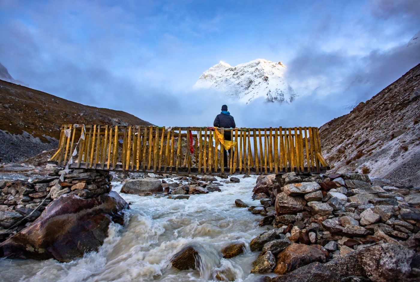
Popular treks around Mount Makalu
The Makalu region offers some of the most remote and rewarding trekking experiences in Nepal, including various deep valleys, high altitude wilderness and adventure in solitude. Some of the treks around Mount Makalu are:
The Classic Makalu Base Camp Trek.
The Classic Makalu Trek is the flagship trekking route of the region, taking you directly to the southern foot of the Makalu mountain. It is a demanding trail known for its dramatic shift from subtropical terraced fields to high altitude glacial landscapes.
- Duration: 16 to 18 days
- Max Altitude: 4,870 meters (15,977 feet) at Makalu Base Camp
- Difficulty: Challenging / Hard
- Highlights: Crossing the snow prone Shipton La Pass (4,210m), exploring the lush meadows of the Barun River Valley, and seeing the sheer south face of Makalu towering right over your tent.
Makalu Base Camp Trek with Nepal Hiking Team
Ready to start your journey? If you are looking to experience Makalu's remote wilderness, the Nepal Hiking Team offers a comprehensive Makalu Base Camp Trek 2026/2027 itinerary.
The Great Himalayan Trail: Makalu to Everest Traverse
For true mountaineers and elite trekkers, the Great Himalayan Trail is one of the most extreme and difficult high altitude treks in the world. It connects the Makalu region directly over the high mountain walls into the Khumbu (Everest) region via technical, glaciated terrain.
- Duration: 22 to 26 days
- Max Altitude: 6,143 meters (20,154 feet) at the West Col.
- Difficulty: Extreme / Mountaineering experience required
- Highlights: Successfully navigating three consecutive "Super Passes", the Sherpani Col (6,135m), West Col (6,143m), and Amphu Laptsa Pass (5,850m), while spending multiple nights camping completely on ice.
The Arun Valley Trek (Salpa Pass Route)
The Arun Valley Trek (Salpa Pass) route avoids the extreme heights of the glacier zone, focusing instead on the deep Arun Valley gorge (one of the deepest river valleys in the world) and rich local heritage. It follows an ancient trading route used before modern roads or airstrips were built.
- Duration: 10 to 12 days
- Max Altitude: 3,350 meters (10,990 feet) at Salpa Pass
- Difficulty: Moderate
- Highlights: Exceptional cultural immersion among the Rai, Limbu, and Sherpa villages, lower altitude trekking through incredible rhododendron forests, and panoramic skyline views of Makalu and Everest from the ridge lines.
Plan your Mount Makalu Trek
The high altitude trek to Makalu is a challenging, remote adventure through eastern Nepal’s uninhabited wilderness. Unlike busier trails, this trek offers quiet solitude and demanding high altitude passes, such as the Shipton La (4,210m), leading to stunning, up close views of the Makalu mountain.
We, the Nepal Hiking Team offer the 19 days Makalu Base Camp Trek 2026/2027, handling all the difficult planning, such as booking your flights. We also manage your regional regulatory compliance and arrange your teahouse stays for your Makalu trekking.
Conclusion
In addition to being the fifth highest peak in the world, standing at an elevation of 8,485 meters (27,838 feet), Mount Makalu represents the untamed beauty of the eastern Himalayas. It is located on the border between Nepal and China. From Nepal, it lies in the Sankhuwasabha District within the Makalu Barun National Park area. In China, it sits in the Tibet Autonomous Region of China. A 19 km stretch separates Mount Makalu from Mount Everest.
The Makalu mountain provides a sense of seclusion that is becoming more and more uncommon in the high altitude world. The journey to Mount Makalu shows the determination of every adventurer. Whether you love its climbing history or the stunning views along the base camp route, it offers something special.
To fully experience the remote landscapes of Makalu, consider the Nepal Hiking Team’s all-inclusive Makalu Base Camp Trek 2026/2027. We manage all permits, logistics, and safety protocols, ensuring you can focus entirely on the journey from Kathmandu to the base of the peak.
Post a Comment