

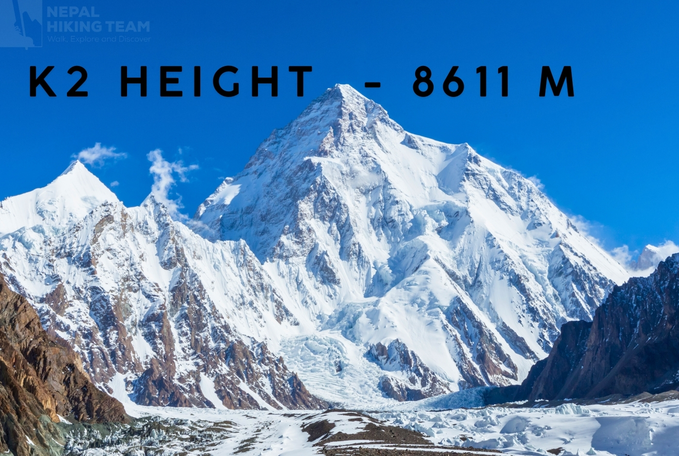
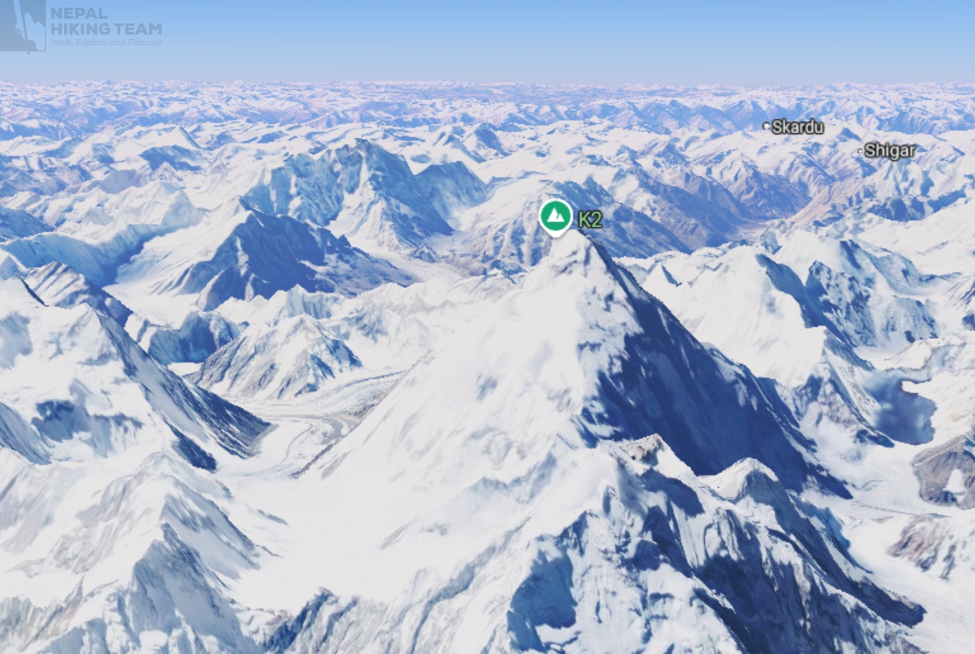
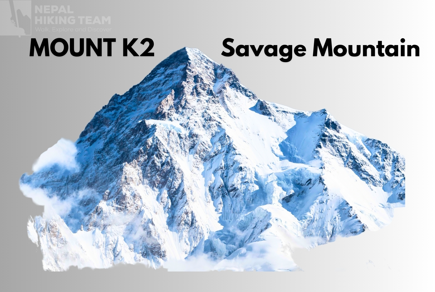
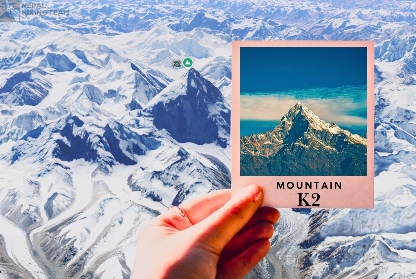
K2, at 8,611 meters (28,251 feet), is the second-highest mountain on Earth. Located in the Karakoram Range on the border between Pakistan and China, it is notoriously known as "The Savage Mountain" due to its extreme technical difficulty, severe weather, and treacherous climbing conditions.
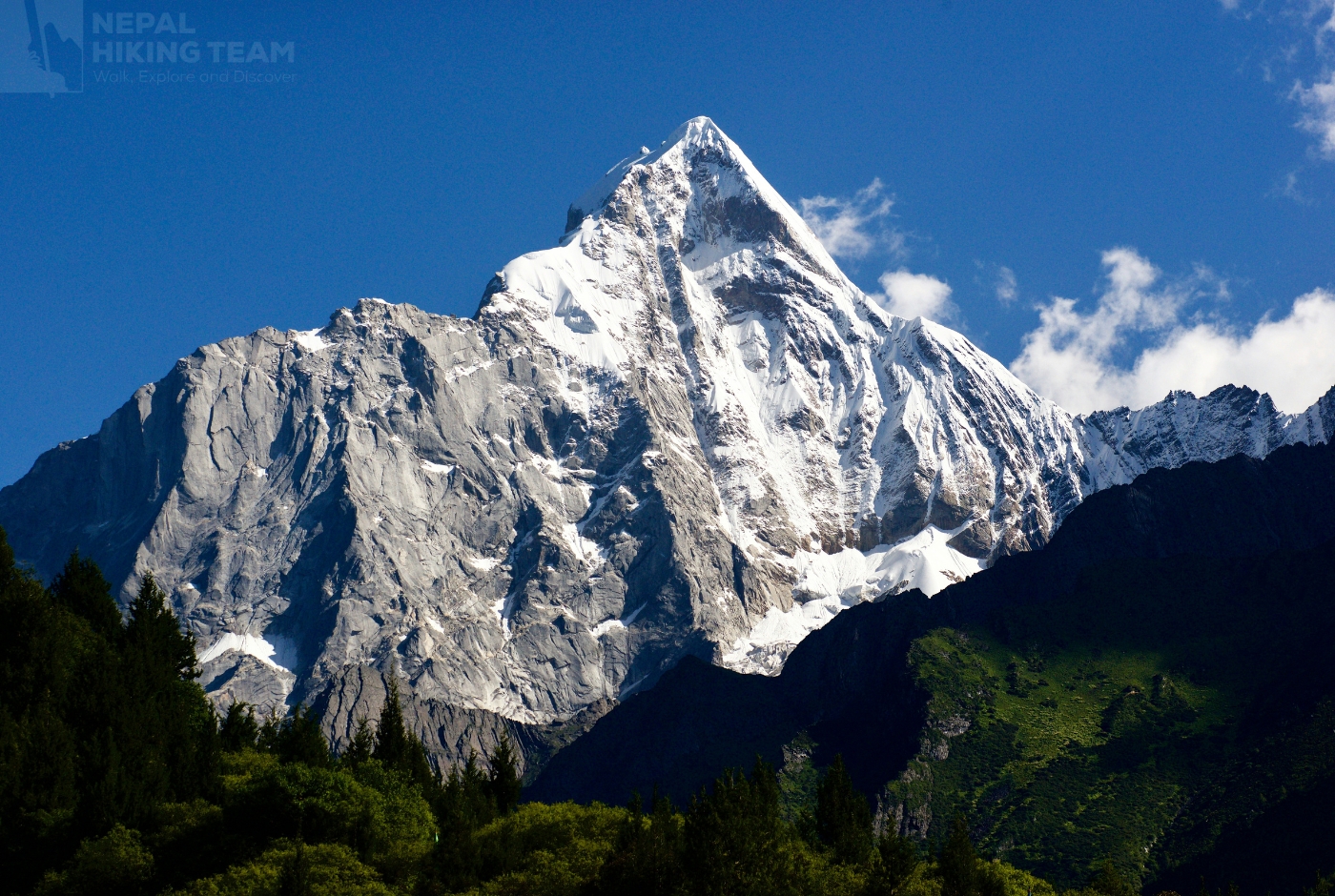
Towering like a serrated crown against the sky, K2 commands awe and respect as the fierce jewel of the Karakoram Range. Often called the "Mountaineer's Mountain," it is the second-highest peak in the world, surpassed only by Everest. However, climbers fear it far more due to its treacherous slopes and pristine, untouched beauty. Known locally as Chogori, this imposing giant symbolizes both a summit and the strength and skill of humanity. To see K2 Himalayan Peak is to witness nature at its most dramatic and fierce; to climb it is to enter a realm reserved for only the most courageous.
K2, also known as Mount Godwin-Austen, is the second-highest mountain in the world, standing at 8,611 meters (28,251 feet). It is located in the Karakoram Range, straddling the border between the Gilgit-Baltistan region of Pakistan and the Xinjiang region of China. K2 is renowned for its extreme difficulty and dangerous conditions, earning it the nickname "Savage Mountain". Because of its remote and desolate location, it lacked a traditional local name and was simply designated "K2" during the Great Trigonometrical Survey of British India. The summit ridge straddles the boundary between the Gilgit-Baltistan region of Pakistan and the Xinjiang region of China.
What is the second-highest mountain in the world after Everest? Is it Mountain K2?
The second-highest mountain in the world is K2. Located on the border between Pakistan and China, it stands at an elevation of 8,611 meters (28,251 feet). It is part of the Karakoram Range and is widely known as the "Savage Mountain" due to its treacherous climbing conditions.
What is K2? The World's Second-Highest Mountain
- Location: K2 mountain is located in the Karakoram Range, straddling the border between China and Pakistan. Specifically, it's in the Baltistan region of Gilgit–Baltistan, Pakistan, and the Taxkorgan Tajik Autonomous County of Xinjiang, China. The mountain's base is primarily within Pakistan, with a smaller portion in China.
- Elevation: 8,611 meters (28,251 feet).
- Difficulty: Widely considered one of the most challenging mountains to climb among the eight-thousanders, due to its steepness, inclement weather, and high fatality rate.
- History: The first summit was reached in 1954 by Achille Compagnoni and Lino Lacedelli of the Italian Karakoram expedition.
- Climbing Routes: K2 has been climbed via almost all of its ridges, including the Abruzzi Spur, which was the route of the first successful ascent.
- Weather: K2 experiences more inclement weather than many other mountains, contributing to its difficult and dangerous nature.
- Fatality Rate: While the number of successful summits is relatively low compared to Everest, K2 has a higher fatality rate per attempt.
- First Ascent: The first successful ascent of K2 was achieved on July 31, 1954, by Achille Compagnoni and Lino Lacedelli, led by Ardito Desio, via the Abruzzi Spur.
The K2's Mount Height: Exact K2 Height
According to official records, K2, the powerful protector of the Karakoram, is 8611 meters (28251 feet) above sea level. Since the mid-20th century, geographers and climbers have generally accepted a specific elevation as the official height of K2. However, in 2014, a collaborative effort by Italian and Pakistani climbers called “K2 60 Years Later” challenged this traditional measurement. Utilizing advanced satellite navigation technology, the team suggested a new height of 8609.02 meters (28,244.8 feet). Although the 2014 expedition introduced a compelling new measurement, most climbers still adhere to the traditional elevation, demonstrating the enduring admiration for K2's majestic height established since the mid-1900s.
K2 Mountain Elevation is 8,611 meters (28,251 feet)
Mount K2, located on the border between Pakistan and China, stands at an official height of 8,611 meters (28,251 feet) above sea level. It is the second-highest mountain in the world, surpassed only by Mount Everest
K2 Mountain Height is 8611m | K2 elevation in feet 28,251 ft, K2 stands at 8,611 meters (28,251 feet) above sea level.
Himalayan Mountains k2 height measurement
The first formal measurement of K2 occurred in 1856 under the guidance of Colonel T.G. Montgomerie, who was part of the Great Trigonometrical Survey of India. During this survey, he labeled the mountain as "K2," signifying it as the second peak identified in the Karakoram Range. Unlike many prominent peaks, K2 does not have a widely recognized local name, underscoring its remote and isolated character.
Details of K2 Elevation in meters, Feet, and Kilometers
| Feature / Camp | Meters (m) | Feet (ft) | Kilometers (km) |
| k2 Summit Height | 8 611 m | 28 251 ft | 8.611 km |
| Bottleneck of K2 | ~8 200 m | ~26,900 ft | ~8.200 km |
| Camp IV (Abruzzi Spur) | ~7 950 m | ~26,089 ft | ~7.950 km |
| Camp III | ~7 200 m | ~23,622 ft | ~7.200 km |
| Camp II | ~6 700 m | ~21,982 ft | ~6.700 km |
| Camp I | ~6 100 m | ~19,928 ft | ~6.100 km |
| Advanced Base Camp (ABC) | ~5 200 m | ~17,060 ft | ~5.200 km |
| Base Camp (South, Godwin–Austen Glacier) | ~4,900–5,150 m | ~16,076–16,900 ft | ~4.900–5.150 km |
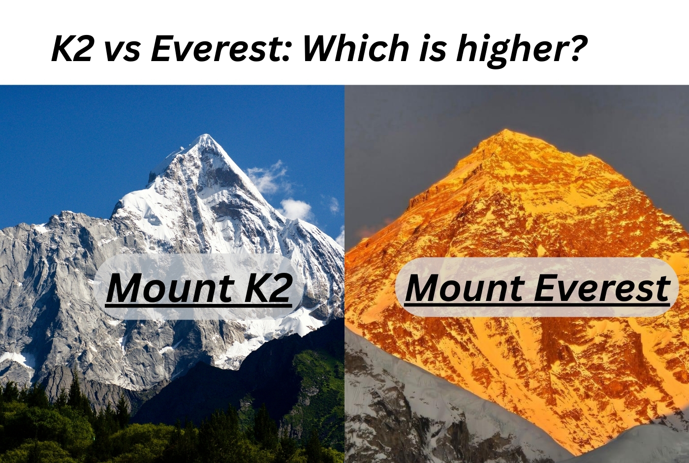
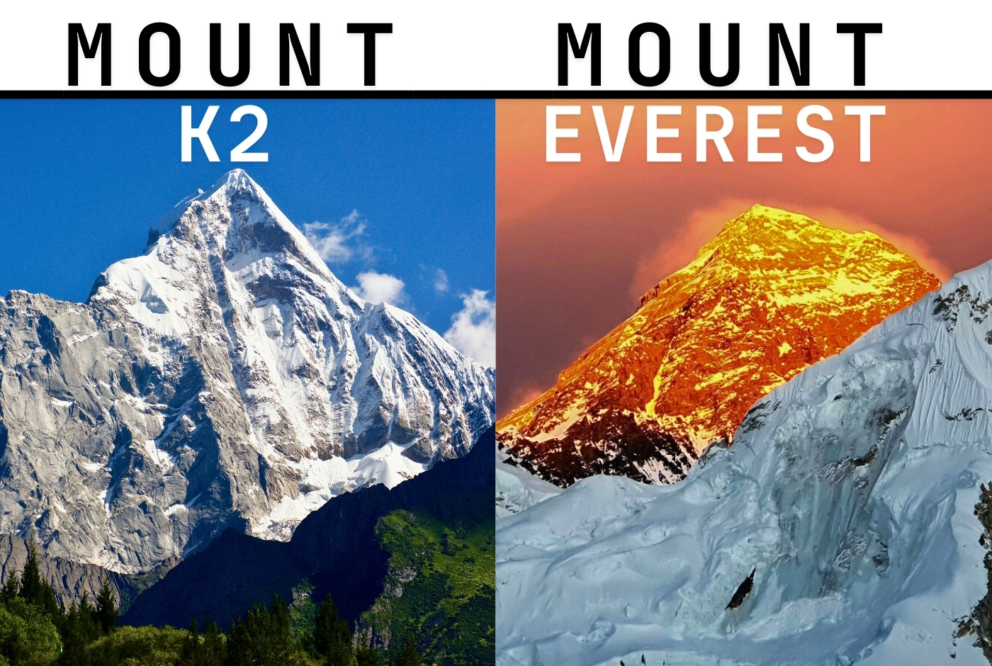
Mount Everest Vs Mount K2 height comparison
When comparing K2 to Mount Everest, known as Sagarmatha in Nepal and Chomolungma in Tibet, the latter reigns as the highest peak in the world at an impressive height of 8,848.86 meters (29,032 feet). The Chinese and Nepalese authorities confirmed this measurement in 2020, which was significant because it confirmed that K2 is approximately 237 meters (778 feet) shorter than Mount Everest. Through this partnership, K2's place among the highest peaks in the world was cemented, and the value of global collaboration in mountaineering research was given importance.
The K2 Mountain Himalayas and The Mount Everest: Which one is higher
Mount Everest is famous for its towering elevation, while K2 is often considered the more challenging climb. Popularly known as the "Savage Mountain," K2 earns its reputation with steep, dangerous terrain, intricate climbing paths, and rapidly changing weather, making the journey incredibly tough. Nevertheless, the climbing community continues to honor the original measurement, reflecting the deep respect for K2's majestic and intimidating presence as one of the world's most iconic natural wonders.
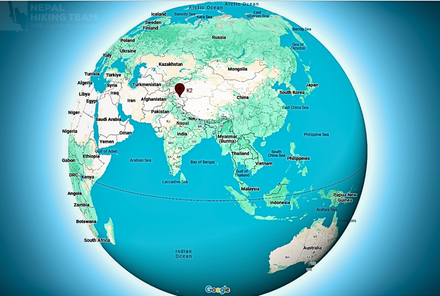
K2 Peak Location: Where is Mount K2?
K2, recognized as the second-highest mountain globally, stands at a height of 8,611 meters (28,251 feet) and is nestled in the heart of the Karakoram Range. Its summit marks the boundary between Pakistan's Gilgit-Baltistan region and China's Taxkorgan Tajik Autonomous County in Xinjiang.
Where is Mount K2 located on the map?
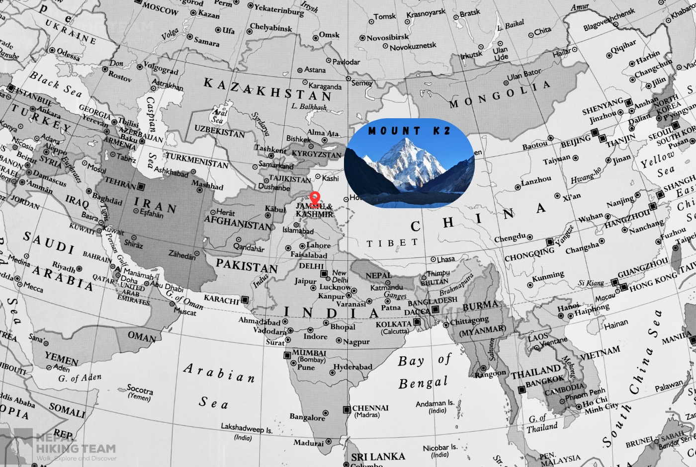
Geographical Location of K2 Peak
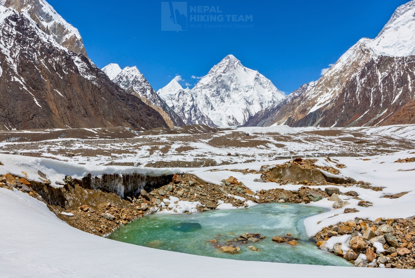
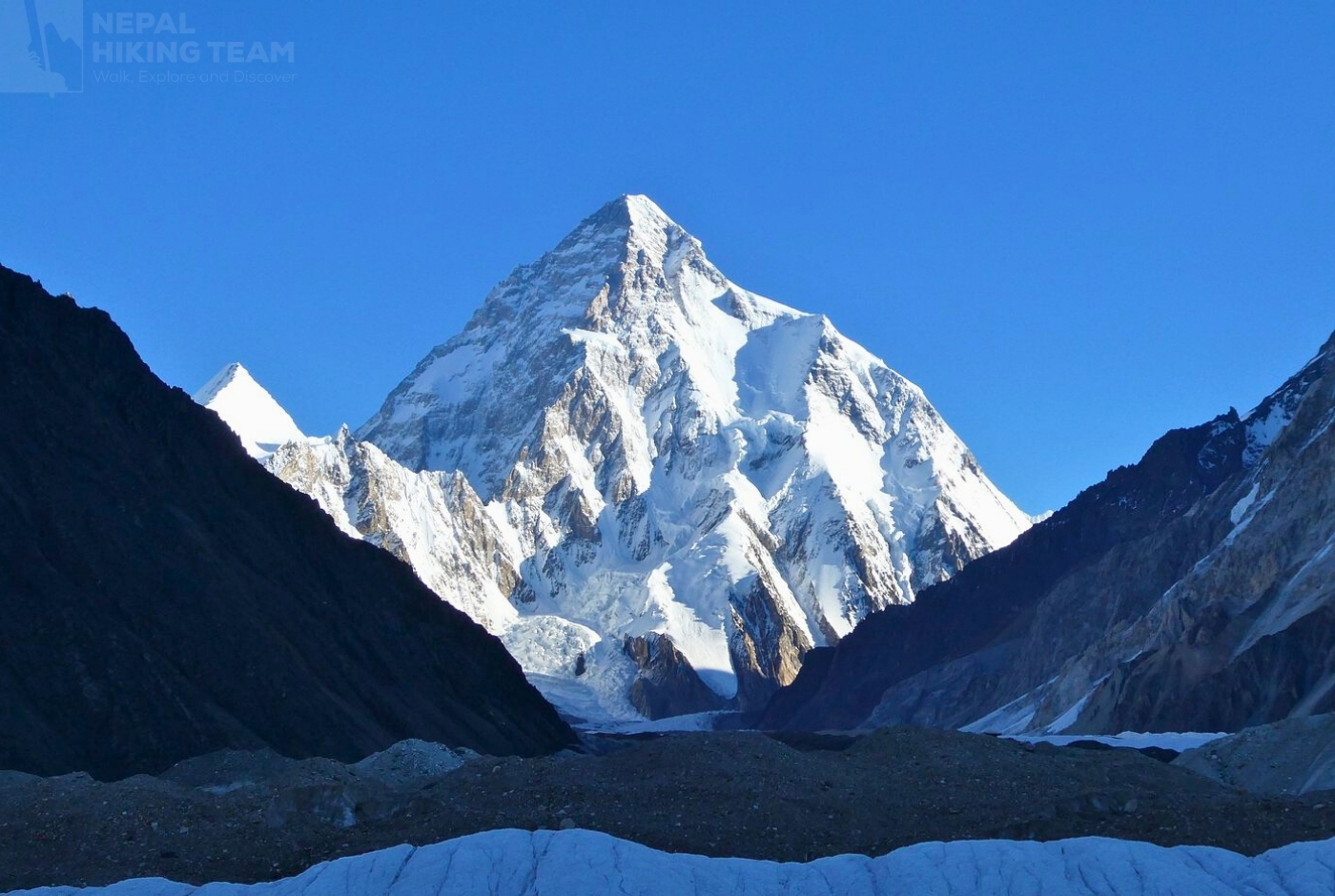
K2 is within the Baltoro Muztagh subrange, a striking part of the larger Karakoram range known for its breathtaking peaks and vast glacial landscapes. The mountain ascends majestically from the Godwin-Austen Glacier, a significant tributary of the Baltoro Glacier, which is widely known as one of the longest glaciers found outside the polar regions. The geographic location of K2 contributes to its potent allure by providing climbers and adventurers with a breathtaking natural environment.
Exact Location: Longitude and latitude
The measurement indicates that K2's precise geographic coordinates are roughly 35°52′57 N latitude and 76°30′48 E longitude. Because of K2, the mountain is in a remote and challenging-to-reach area, which adds to its mystique for climbers.
The Shigar District of Gilgit-Baltistan, renowned for its mountainous landscape and diverse culture, is administratively situated in the Pakistani side of K2. On the other hand, the Chinese side is located in Xinjiang's Taxkorgan Tajik Autonomous County, known for its ethnic Tajik population and high-altitude landscapes.
Furthermore, the geopolitical significance of K2 mountain is heightened by its dual-national positioning while highlighting how collaboration is frequently required for scientific research expeditions and regional conservation efforts. Ultimately, the dual-national aspect of K2 serves as a reminder of how interconnected our efforts can be when exploring and preserving such magnificent environments.
- Border Location: 35°52′57″ North, 76°30′48″ East. The southern/Pakistan-administered side is the most heavily utilized approach.
- Nearest City (Pakistan): Skardu is the primary staging city for K2 expeditions.
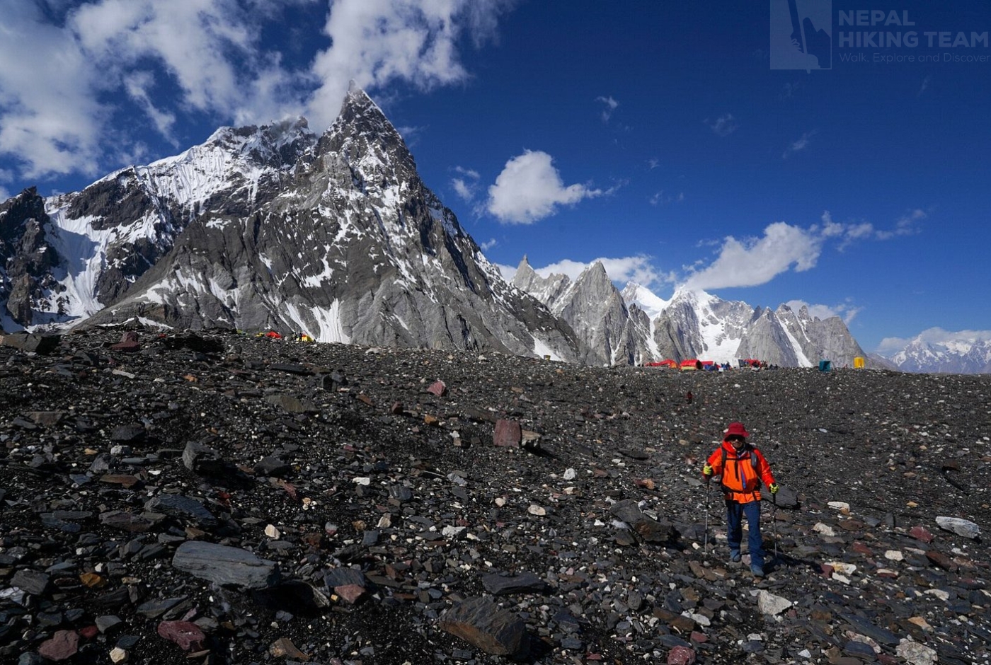
- Base Camp Access: Treks typically begin from Askole and follow the Baltoro Glacier, passing by landmarks like Concordia to reach the base of the mountain.
- Alternative Names: Known locally as Chogori (Balti for "King of Mountains") or Mt. Godwin-Austen.
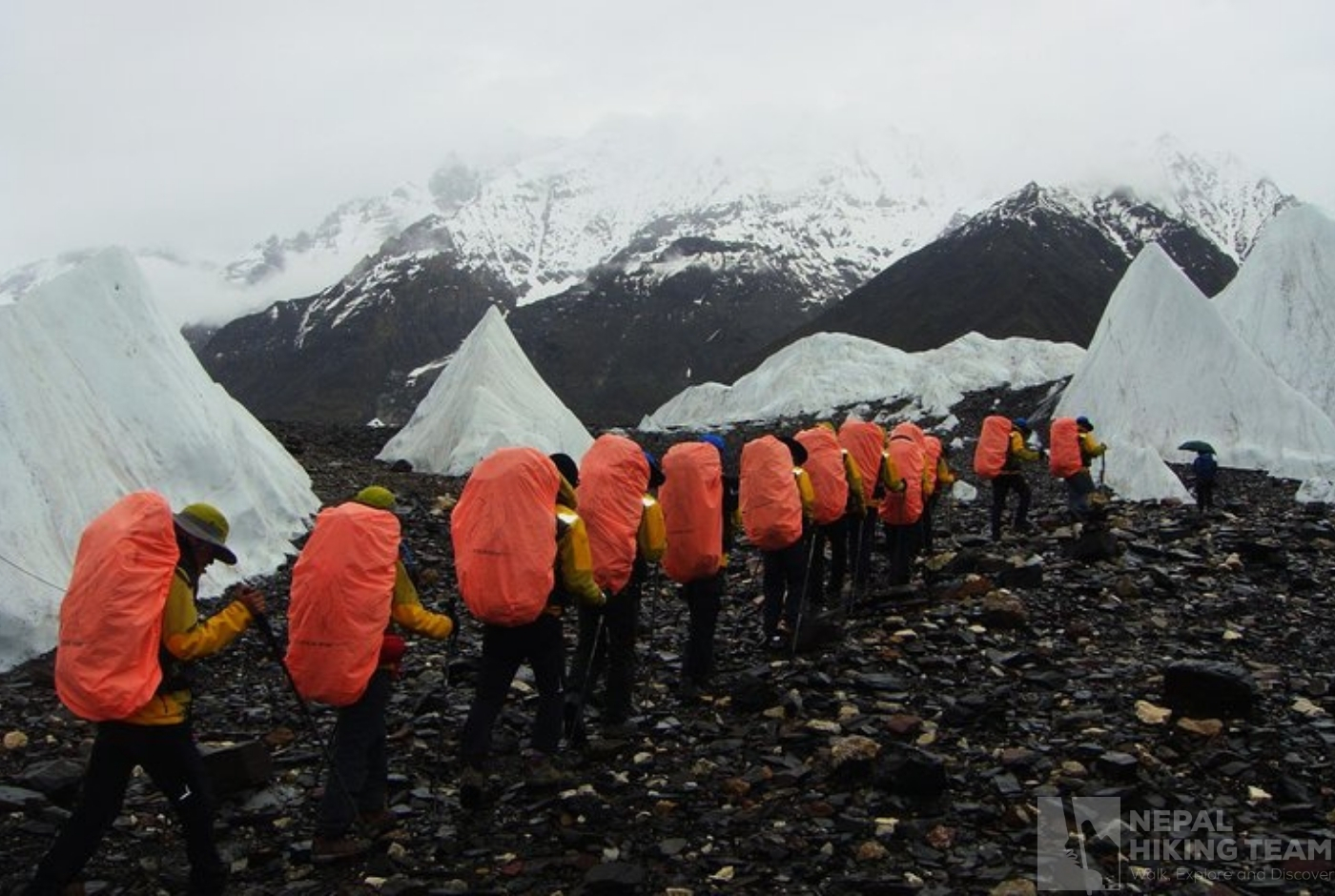
K2 Base or K2 Base Camp
The K2 Base Camp Trek is a legendary, high-altitude expedition in the Karakoram Range of Pakistan. It takes trekkers across the rugged Baltoro Glacier to Concordia, often called the "Throne Room of the Mountain Gods," where four of the world's 8,000-meter peaks converge.
Essential Trip Details
- Total Distance: Approximately 160 to 184 km (100–114 miles) round-trip from the village of Askole.
- Duration: Typically 12 to 14 days of active trekking, though full tour itineraries span 20 to 22 days to include international flights, internal travel, and essential acclimatization rest days.
- Maximum Elevation: 5,150 meters (16,900 feet) at K2 Base Camp.
- Cost Range: International packages generally cost between $2,000 and $4,500+ USD. This price heavily depends on logistics, group sizes, and choices of local operators
Naming of K2: Mt. Godwin Austen
K2 received the name Mount Godwin-Austen to honor Henry Haversham Godwin-Austen, an early 19th-century British surveyor. However, the Royal Geographical Society rejected the honorary title, and the mountain retained its original survey designation, which uses the letter K for the Karakoram range and 2 as the second peak identified.
The designated name "K2" has its roots in the Great Trigonometrical Survey of British India conducted in 1856. Upon observing the Karakoram range from Mount Haramukh—approximately 210 kilometers to the south, Surveyor Thomas Montgomerie designated the two most prominent peaks as K1 and K2, with "K" denoting the Karakoram Range. While K1 was later identified by its local name, Masherbrum, K2 appears to lack a regional designation, likely due to its remote location and limited visibility from nearby communities.
What does K2 mean? Mt.godwin Austen: where is mount godwin austen
Over the years, various alternative names for K2 have emerged. One of the most notable is "Chogori," which comes from the Balti words "chhogo," meaning "big," and "ri," meaning "mountain." While this name has been proposed as a local designation, there is limited evidence to suggest that the local communities widely used it; Western explorers may have introduced it in their quest to chart the region. Interestingly, this name also inspired the Chinese term "Qogir" (乔戈里峰), which is the official designation used by Chinese authorities.
In addition to Chogori, other names like Lamba Pahar, which translates to "Tall Mountain" in Urdu, and Dapsang have been noted, though they aren't commonly used today. Another name, Mount Godwin-Austen, was put forward to honor Henry Godwin-Austen, one of the area's early explorers.
The Royal Geographical Society eventually rejected this designation, but with its appearances on several maps, it is still occasionally used today. The significance of the mountain in local culture and the history of exploration worldwide is highlighted by these names, reflecting the region's rich exploration history and the lasting legacy of those who ventured through its rugged terrain.
Despite the numerous other names K2 has continued to be the most widely used designation and is now also accepted in the Balti language as Kechu or Ketu. Italian mountaineer Fosco Maraini says the name K2, which is stark and a little aloof, perfectly describes the mountain's remote and imposing nature.
History of K2 Himalayan peak
K2, which stands at 8611 meters (28251 feet) as the second-highest peak in the world, has a long history of exploration, accomplishment, and controversy.
Early Exploration and Naming: Name of K2
In 1856, British surveyor Thomas Montgomerie, while carrying out the Great Trigonometrical Survey of India, identified and named the mountain "K2," as it was the second peak documented in the Karakoram Range. This majestic giant represents a physical peak and the strength and skill required to conquer it. Interestingly, K2 did not have a local name, likely because of its remote position and the fact that it was not easily seen from nearby towns. Later, in honor of Colonel A. H. Godwin-Austen—a pioneering local explorer—the name "Mount Godwin-Austen" was suggested for the peak. However, the name K2 remains the one that continues to capture the curiosity and imagination of adventurers worldwide.
History of Climbing K2 Himalayan Peak
The First Ascent: 1954 Italian Expedition
On July 31, 1954, Italian climbers Achille Compagnoni and Lino Lacedelli achieved the first successful ascent of K2 during an expedition led by Ardito Desio. Their journey was fraught with numerous challenges, including treacherous terrain and extreme weather conditions, underscoring the mountain's reputation as one of the world's most difficult and dangerous climbs. A significant controversy arose involving team member Walter Bonatti and Pakistani climber Amir Mehdi, who was responsible for transporting oxygen bottles to the high camp, and the notable miscommunication forced climbers Walter Bonatti and Amir Mehdi to spend a harrowing night at 8,100 meters without proper shelter, resulting in Mehdi suffering frostbite. The decisions made during the K2 expedition became controversial; however, over time, Bonatti's viewpoint was supported by evidence of the tremendous difficulties and complexities climbers encounter in the harsh environment of K2.
Subsequent Expeditions and Notable Ascents
Many climbers consider K2 formidable after the first historic ascent in 1954. The reputation of K2 as a dangerous climb has persisted since Jim Whittaker led the first successful American summit in 1978. Numerous expeditions have encountered difficult conditions and a high death rate. Every attempt demonstrates the mountain's unpredictable nature and the tenacity of climbers attracted to its thrilling adventure.
The first winter ascent of K2 was accomplished on January 16, 2021, by outstanding Nepali climbers, including the well-known Nirmal Nims Purja. This milestone was especially noteworthy, as K2 was the final peak among the 14 eight-thousanders to be conquered during winter.
K2's legacy is a tribute to human resilience and the unwavering quest for discovery, reinforcing its reputation as one of the most formidable and esteemed summits in mountaineering history.
K2 Geological Composition
Powerful tectonic forces sculpted the ancient rocks that comprise K2's geological composition. The mountain mainly comprises K2 Gneiss, a metamorphic rock formed in the Cretaceous from granitic materials. This gneiss reveals a history of deep burial, intense heat, and considerable pressure, which combines orthogneiss and biotite-rich paragneiss.
Leucogranitic and lamprophyre dikes, which highlight different stages of geological activity that have taken place over time, also add complexity to the region's geological structure.
Impure marbles, mica schists, and quartzites occasionally enhance the complex stratigraphy of the mountain. These formations demonstrate the dynamic forces that have shaped K2 over millions of years, which are the remains of sedimentary rocks that have undergone metamorphic processes. K2 is evidence of the Earth's dynamic geological past and the enduring force of nature.
Physical Features: The Savage Mountain's Rugged Majesty
The steep pyramid-like profile of K2, which features ridges and faces that pose serious challenges to even the most experienced climbers, defines its physical attributes. The mountain rises roughly 3600 meters (11811 feet) from its base, approximately 5000 meters (16404 feet) above sea level.
Mount K2 Map: What is K2?
Notable Ridges and Faces of Peak K2:
- Abruzzi Spur (Southeast Ridge): The most commonly taken route for climbing, the K2 features steep sections and technical difficulties that challenge climbers' skills.
- North Ridge: This route is less popular among climbers but is well-known for its steep ridges and exposure to strong winds.
- West Face: As a sheer vertical wall, this route on K2 poses significant technical challenges, causing it to be rarely attempted because of its difficulty and inherent dangers.
The mountain's slopes of K2 are marked by glacial valleys, cirques, and cliffs, all sculpted by the enduring power of glacial activity throughout the years. Each feature adds to the mountain's allure while simultaneously posing risks that require careful navigation and respect from adventurers.
Glaciers and Icefalls: The Icy Sentinels of K2
K2 is surrounded by some of the largest glacial systems outside the polar regions. Its southern neighbor, Godwin-Austen Glacier, is a major expeditionary route. The K2 (Qogir) Glacier drops sharply to the north, striking relief to the mountains.
In addition to their size, these glaciers are essential because they influence the landscape. Standard posing features include crevasses, seracs, and icefalls, which pose ongoing dangers to climbers and affect the routes chosen for ascents.
Tectonic Setting: A Product of Continental Collision
K2 was created as a direct result of the tremendous ongoing collision between the Eurasian and Indian tectonic plates. K2 is the most notable peak in the Karakoram Range, which has been elevated due to this convergence. The mountain has been raised to extraordinary heights by the tremendous pressures and forces brought about by this tectonic interaction, which has also largely contributed to the development of its intricate geological features. As a result, K2 is a powerful illustration of the complex processes of geological evolution over time.
K2 Weather and Temperature
The second-tallest mountain in the world, K2, has severe and erratic weather all year. Its climate is infamously harsh and variable, with distinct seasons significantly impacting climbing conditions. Generally, the region experiences four distinct seasons: a cold and dry period (December to February), a hot and dry season (March to May), a summer/rainy season (June to September), and a monsoon phase (October to November). During winter, temperatures at Base Camp can drop to as low as -30°C, while hurricane-force winds are not uncommon at the summit. To successfully traverse this rugged terrain, climbers and trekkers should have a solid grasp of its seasonal climate.
K2 mt.: Second tallest mountain in the Earth
Spring (March to May): The spring season ushers in increasing precipitation, with April averaging around 18 snow days. The weather remains unstable, and visibility often suffers, making climbing difficult. Temperatures at Base Camp can be low, and the risk of avalanches escalates due to melting snow.
Summer (June to August): This period is generally considered the optimal climbing season. July and August provide relatively stable weather, with daytime temperatures at Base Camp fluctuating between 0°C and 30°C, while nighttime temperatures range from -10°C to 10°C. However, sudden storms can emerge, and the risk of avalanches can persist.
Autumn (September to November): In the fall, the temperature drops and the wind speed increases. Base Camp temperatures can drop to -25°C by October, and the mountain season starts. Changing to its winter climate pattern, the cold weather increases the risk of climbing and erratic weather conditions.
Winter (December to February): The winter on K2 is defined by extreme cold and powerful winds. During daylight hours, temperatures at Base Camp can reach as low as -30°C; at night, they can drop further to -40°C. Temperatures can drop below -65°C at the summit, and hurricane-force winds are common. Because of these dangerous circumstances, climbing is hazardous and dramatically increases the chance of hypothermia and frostbite.
Major Climbing Routes on K2
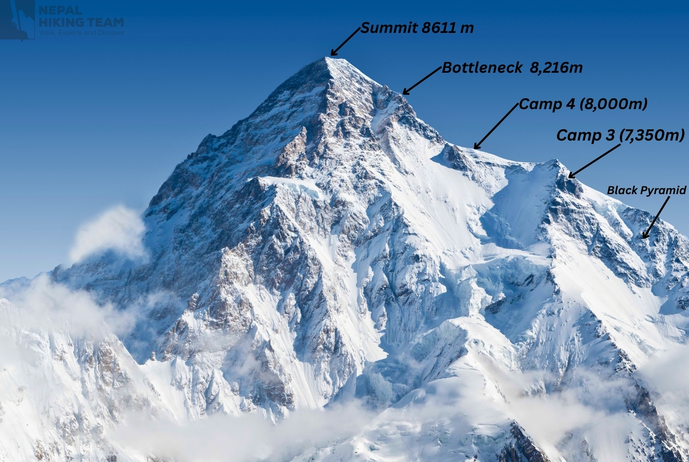
Abruzzi Spur (Southeast Ridge of Mt. K2)
The Abruzzi Spur stands out as the favored path for climbers, with about three-quarters opting for this route. Its history dates back to 1909 when Prince Luigi Amedeo, the Duke of the Abruzzi, made the first attempt to conquer it. In 1954, an Italian expedition finally reached the summit via the Abruzzi Spur, a route renowned for its difficult landmarks such as House's Chimney, the Black Pyramid, and especially the Bottleneck—a narrow, steep passage beneath overhanging seracs. This portion of the ascent is considered the riskiest since it calls for courage and skill despite the mountain's unreadable conditions. After conquering these incredible obstacles, climbers feel great satisfaction and joy.
Česen Route (South-Southeast Spur)
A group from the Basque region of Spain made the first ascent of the Česen Route, also known as the Basque Route, in 1994. Compared to the Abruzzi Spur, this path is distinguished by its steeper incline and increased avalanche risk. However, some mountaineers prefer it because it avoids the Black Pyramid. Above Camp III, the Abruzzi Spur and the Česen Route finally meet.
North Ridge
Due to its significant technical difficulties and challenging accessibility, including the treacherous crossing of the Shaksgam River, theNorth Ridge, which is approached from the Chinese side, is rarely tried. The ascent is challenging because of the treacherous traverse across a suspended glacier and the steep rock faces along this route.
Where is K2? Where is the base of Mount k2 located?
Northeast Ridge
In 1978, an American expedition made the first successful ascent of the Northeast Ridge is known for its steep icy slopes and broad corniced ridges. The upper portion of the Abruzzi Spur eventually meets this difficult path. Remarkably famed mountaineer Reinhold Messner called it suicidal,emphasizing the grave dangers for climbers.
Southwest Pillar (Magic Line)
One of the most difficult and technically demanding routes on K2, the Magic Line is renowned for its considerable exposure and difficulty. Since a Polish-Slovak expedition first successfully ascended this route in 1986, it has only seen a small number of successful ascents, highlighting its formidable reputation among mountaineers. The unpredictable hazards and disjointed nature of this route test the potential and resilience of each climber.
South Face (Polish Line)
Many consider the Polish Line, or the Central Rib, one of the riskiest K2 routes. Only once in 1986 did climbers Jerzy Kukuczka and Tadeusz Piotrowski successfully ascend it. There are areas of this path that are highly exposed and avalanche-prone. The route is characterized by exposed, avalanche-prone terrain, which proved deadly when climber Piotrowski tragically lost his life during the descent.
West Face
The less-traveled and extremely technical West Face route. In 2007, a Russian team first climbed it. In 2024, the Japanese climbers Kenro and Kazuya Hiraide 2024 tragically vanished during their ascent after attempting a new line on this face.
Each path to K2 presents its own set of formidable challenges. Before attempting the ascent climbers must thoroughly evaluate their skills, experience, and current conditions. K2's well-deserved nickname, the "Savage Mountain," highlights the critical need for careful planning and preparation on any expedition.
Climbing Challenges: Why is K2 so dangerous?
Climbing Mount K2, the second-tallest mountain in the world at 8611 meters (28251 feet), is considered one of the most difficult mountaineering challenges. Known as the "Savage Mountain," K2's notorious nickname reflects its extremely high fatality rate, unpredictable weather, and immense technical challenges, as highlighted by its perilous slopes, avalanche-prone terrain, and the many risks climbers have faced throughout history.
Technical Difficulties
K2 is renowned for its relentless steepness and technical difficulty, with exposed ridges and challenging sections from base to summit, unlike Mount Everest's gentler slopes. The most popular route, the Abruzzi Spur, chosen by about 75% of climbers, includes significant obstacles such as House's Chimney, the Black Pyramid, and the perilous Bottleneck—a narrow passage beneath unstable seracs that caused a deadly accident in 2008, claiming 11 lives.
Why is Mount K2 so dangerous? Why it is called Savage Mountain?
Unpredictable Weather
K2's isolated and untamed terrain makes rescue efforts extremely challenging since helicopter evacuations are frequently not feasible at higher elevations. The climbers must therefore depend heavily on their expedition teams for emergency support. Considering K2's treacherous slopes, avalanche-prone routes, and unpredictable weather, the grim death toll, estimated at around 96 according to recent updates, highlights the enormous risks involved in attempting to scale this harsh and unforgiving peak, famously known for its perilous nature.
High Fatality Rate
K2, due to its brutal conditions, has one of the highest fatality rates among the eight-thousanders peaks of the world. In sharp contrast to Everest's significantly lower death rate of 3%, the mountain's death rate stands at roughly 18%, with about 96 climbers having died. This grim statistic reflects the extreme dangers posed by K2's treacherous slopes.
Altitude-Related Health Risks
High Altitude Pulmonary Edema (HAPE) and High Altitude Cerebral Edema (HACE) are two significant health risks of climbing K2. These potentially fatal conditions can be deadly if treatment is delayed. The extreme physical strain considerably increases these risks and inadequate acclimatization, making K2 challenging even for experienced climbers.
Remote Location and Limited Support
K2's isolated location in the far-flung Karakoram Range poses serious logistical challenges with little infrastructure and assistance for climbers. Rescue operations become incredibly complicated and time-consuming during emergencies, and they frequently rely on favorable weather conditions to be carried out safely.
Characterized by limited infrastructure and challenging access, coupled with the mountain's isolated position in the Karakoram Range, the trekking endeavor is daunting even for the most experienced trekkers.
K2 Deaths
K2, positioned at 8,611 meters (28,251 feet) as the world's second-tallest peak, is infamous for its extreme difficulties and significant mortality rate. By August 2023, roughly 800 mountaineers had successfully reached its summit, whereas around 96 climbers had perished in the attempt, reflecting an overall fatality rate of nearly 12%.
Notable Tragedies of k2 Deaths
- 1986 K2 Catastrophe: The 1986 climbing season proved exceptionally deadly with the loss of thirteen climbers, making it one of the most pernicious in the history of the mountain.
- 2008 K2 Disaster: On August 1, 2008, a devastating ice avalanche struck the Bottleneck area of K2, cutting fixed ropes and trapping climbers in one of the most hazardous parts of the mountain. This date is remembered as tragic, as it resulted in the deaths of eleven climbers from various international expeditions.
- 1995 K2 Storm: Alison Hargreaves, a well-known British mountaineer, was one of seven climbers who died in an unexpected storm with strong winds.
- 2021 Winter Tragedy: During a winter ascent on February 5, 2021, three experienced climbers—Ali Sadpara of Pakistan, John Snorri from Iceland, and Chilean Juan Pablo Mohr—went missing. Their bodies were recovered months later near the perilous Bottleneck section.
Fatality Rate and Comparison
Throughout its climbing history, K2 has stood out as one of the most lethal of the world's fourteen eight-thousand-meter peaks. Before 2021, K2's fatality rate stood at around 25%, which meant that one climber died for every four who made it to the top. However, advancements in weather forecasting and climbing techniques have led to a significant decrease in this rate. By 2021, the fatality rate had dropped to approximately 13%, reflecting notable improvements in safety on this notoriously dangerous peak.
In contrast, Mount Everest—the tallest peak on Earth—has a significantly lower fatality rate of approximately 3.9%, with 223 recorded deaths among 5,656 successful summits.
K2 Bottleneck
The Bottleneck on K2 is widely recognized as one of the most dangerous challenges in high-altitude climbing. Situated about 400 meters beneath the summit, this narrow, steep couloir features slopes ranging from 50 to 60 degrees. It lies directly beneath towering seracs—immense ice cliffs that are highly unstable and pose a continual risk of sudden collapse.
Climbers traversing the Bottleneck on K2 confront a range of serious dangers. The constant threat of collapsing seracs—massive, unstable ice cliffs—along with avalanches and falling rocks, makes this section exceptionally perilous. High altitude-related diseases like fatigue are made worse by extreme altitude, at about 8200 meters. The limited width of the Bottleneck causes climbers to slow down, considerably lengthening their time in this dangerous area. This delay increases the perils of climbing the Savage Mountain, K2's constant technical issues, and the high altitude risks.
Bottleneck remains the most straightforward and popular route to summit K2 as of 2025, drawing plenty of climbers each season despite this area's high fatalities.
The tragic death of Pakistani porter Muhammad Hassan in 2023 has drawn attention to the serious dangers involved in this portion of the climb and the pressing need for stronger safety protocols and moral guidelines.
As of 2025, the Bottleneck continues to be the most challenging and dangerous section of K2, consistently pushing climbers' stamina and judgment to their limits.
Mount K2 Himalayan Peak| Photo of K2 peak
10 known and unknown facts & secrets about K2 Himalaya
- Mount K2, 8,611 meters (28,251 feet), is celebrated as the world's second-tallest mountain and has a deadly reputation. While many know of its height, several unique and lesser-known aspects underscore its formidable nature:
- The Name K2 Originated from a Survey Notation: In 1856, as part of the Great Trigonometrical Survey of India, British surveyor Thomas Montgomerie assigned alphanumeric labels like K1 and K2 to peaks in the Karakoram range. There was no known local name for K2; however, it retained its alphanumeric name when it was later known as Masherbrum.
- K2’s Eastern Face Remains Unclimbed- “The Unconquered Eastern Face”: K2's eastern face remains unclimbed due to its extreme steepness and high avalanche risk, with many attempts in the past, making it one of the most challenging sections on the mountain.
- The 'Savage Mountain' Moniker: The mountain earned the moniker "Savage Mountain" after American climber George Bell described it as "a savage mountain that tries to kill you" following a 1953 expedition, a testament to its harsh conditions and technical difficulties.
- Historic First Winter Ascent in 2021: For decades, K2 was the only eight-thousander that had never been summited during winter. This changed on January 16, 2021, when Nepali climbers—including Nirmal Purja and Mingma Gyalje Sherpa—successfully reached the peak under severe winter conditions.
- One of the Highest Fatality Rates Among Eight-Thousanders: Before 2021, K2 had an alarmingly high death rate, with roughly one fatality for every four successful ascents, reflecting the mountain's extreme hazards, including technical climbing, volatile weather, and altitude sickness risks.
- First Ski Descent in 2018: In a remarkable feat, Polish ski mountaineer Andrzej Bargiel accomplished an impressive feat by making the first-ever ski descent from the summit of K2 to base camp in 2018, despite the hazardous slopes without taking off his skis.
- Home to the 'Bottleneck'—A Treacherous Passage: Located about 400 meters below the summit, huge unstable ice seracs cast a shadow over the Bottleneck, a narrow, steep couloir approximately 400 meters below the summit. This area's hazards are well known, including the possibility of avalanches and ice collapses.
- Disputed Territorial Location: K2, located between Pakistan's Gilgit-Baltistan and China's Xinjiang, remains difficult to access due to political tensions, adding complexities to trekking expeditions and accessing the route.
- Limited Use of Supplemental Oxygen: Many mountaineers climb K2 without supplemental oxygen, unlike Everest, where most climbers use it. These attempts are particularly challenging due to K2's extreme weather, technical difficulty, and the deadly challenges of the routes.
- Fewer Successful Summits of Mount Everest: The most recent data shows that fewer than 400 people have climbed to the top of K2, starkly contrasting the thousands who have climbed Mount Everest. This discrepancy highlights K2's standing as a much harder and less frequently attempted peak.
Central Karakoram National K2's (CKNP)
Established in 1993, the Central Karakoram National Park (CKNP) covers an area exceeding 10,557 square kilometers, making it the largest conservation zone in Pakistan. The park includes K2 and numerous other towering peaks and features a wide range of elevations, from 2,000 meters up to more than 8,000 meters above sea level. The CKNPs Baltoro, Panmah, Biafo, and Hispar glaciers are some of the largest glaciers outside the world's polar regions. In 2015 following international consultations, a comprehensive park management strategy was finalized to bring a robust framework related to wildlife, plant life, tourism, and waste management required for complex expeditions such as climbing K2.
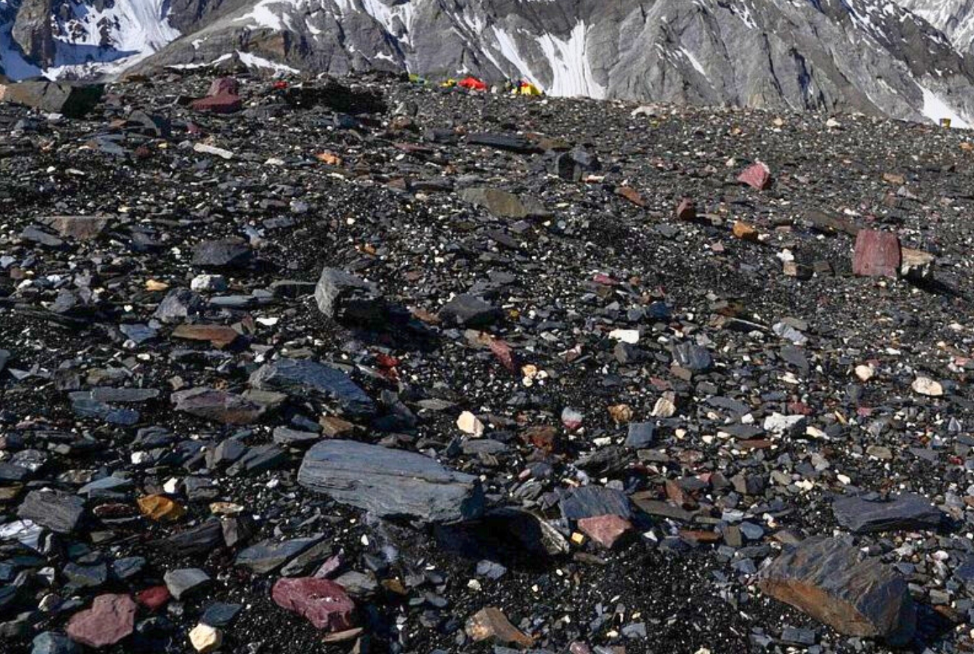
World's Management and Cleanup Initiatives
An increase in waste accumulation has resulted from the surge in trekking and mountaineering activities. The territory. "The Karakorum Green and Clean "campaign was started to address this, focusing on cleaning the high camps at K2 and the Baltoro Glacier. One of its major initiatives was the campaign. Reached altitudes of up to 13 tons of waste, including 2800 kilograms of human waste. 7800m.
A global mountain cleanup initiative by the Mashreq Bank was launched in 2024, focusing on K2 and Broad Peak. Prominent climbers and local volunteers participated in the cleanup campaign to preserve these natural areas, including base camps and the high-altitude areas.
Community Engagement and Sustainable Tourism
The efforts of conservation carried out by the local communities play a pivotal role through programs that educate and engage residents in sustainable practices. These initiatives aim to balance tourism's economic benefits with environmental protection. Information on responsible trekking, tourism's disposal, and energy-saving practices is shared with tourists and tour operators to encourage environmentally conscious behavior and help safeguard the fragile mountain ecosystems.
International Collaborations and Research
International collaborations have been established to support conservation initiatives in recognition of the Karakoram region's global significance. Italy has demonstrated helpful strategies for cross-border environmental protection by playing a significant role in glacier research and preservation projects.
Also active in the area are groups such as the World Wildlife Fund (WWF). These groups are supportive of sustainable development and the defense of delicate ecosystems.
Mount K2 vs Mount Everest
Mount Everest, towering 8,848.86 meters (29,031.7 feet), holds the world's tallest mountain title and straddles the border between Nepal and China. K2, the second-highest peak at 8,611 meters (28,251 feet), rises dramatically within the Karakoram range along the Pakistan-China boundary. While Everest draws more climbers due to its global renown and relatively less demanding terrain, K2 is known for being considerably more technical and perilous.
Unlike the challenging K2 with its deadly Bottleneck and harsh conditions, Everest offers a comparatively more straightforward climb, especially via the South Col route from Nepal. This route includes well-established camps offering rest, backed by solid infrastructure such as fixed ropes and skilled Sherpa guides, making the climb more accessible, allowing roughly 50 to 60 percent of climbers to reach the summit.
Mount Everest and Mount K2: Comparison of two highest peak
Conversely, K2 necessitates constant effort over rough, steep slopes with few peaks. Its terrain is a problematic combination of ice, rock, and areas vulnerable to avalanches, making every step more difficult. Strong winds and bitter cold are among the infamously abrupt and severe mountain weather changes, often forcing climbers to wait out storms for days. Even though K2 has a success rate of roughly 25%, it still has a much higher death rate than Everest.
Additionally, K2's risk is increased by less reliable fixed ropes and inadequate support infrastructure. Since K2's mountain is so far away and the area is politically sensitive, climbers frequently have to rely primarily on themselves, with few options for rescue.
Popular trekking expeditions such as the Everest Base Camp Trek, Gokyo Lakes Trek, and Three Passes Trek offer immersive, non-technical adventures in the Everest area. These treks provide breathtaking views of Everest, cultural experiences in Sherpa villages, and a journey through Sagarmatha National Park.
Nonetheless, the Baltoro Glacier Trek to Concordia and K2 Base Camp is the most popular in the K2 region. This route passes well-known peaks such as Broad Peak, the Gasherbrums, and the Trango Towers. Longer travel times and more thorough logistical planning are necessary because of its increased remoteness and ruggedness.
Both mountains provide exhilarating high-altitude experiences; however, Everest, with its greater accessibility and well-established infrastructure, contrasts with K2, which draws seasoned climbers eager for a tougher, more demanding ascent.
Mount K2 in different Names and according to Countries
Mount K2 is known by different names in different countries and languages, although K2 remains the most widely used name worldwide. In Pakistan, local Balti people call it Chhogori, while in China it is known as Qogir in Uyghur and Ketu (乔戈里峰 / Qiáogēlǐ Fēng) in Mandarin Chinese. Despite these regional names, K2 is the internationally recognized and official name used across most languages and countries.
| Country/Region | Language | Name of K2 | Native Script | Notes |
|---|---|---|---|---|
| International | English | K2 | K2 | Official and most widely used international name. |
| Pakistan (Baltistan) | Balti | Chhogori | ཆོགོ་རི (Tibetan script, where used) | Traditional local name, often translated as "Great Mountain." |
| China (Xinjiang) | Uyghur | Qogir | قوگىر تاغ | Official Uyghur name used in Xinjiang. |
| China | Mandarin Chinese | Ketu | 乔戈里峰 (Qiáogēlǐ Fēng) | Official Chinese name. 峰 (Fēng) means "peak." |
| Pakistan | Urdu | K2 | کے ٹو | The international name written in Urdu script. |
| India | Hindi | K2 | के2 | Uses the international name in Devanagari script. |
| Nepal | Nepali | K2 | के२ | Uses the international name in Nepali script. |
| Russia | Russian | K2 | К2 | Russian transliteration of the international name. |
| Japan | Japanese | K2 | K2 / ケーツー | Written in Latin letters or Katakana. |
| South Korea | Korean | K2 | K2 / 케이투 | Common Korean rendering of the international name. |
| France | French | K2 | K2 | Uses the international name. |
| Germany | German | K2 | K2 | Uses the international name. |
| Spain | Spanish | K2 | K2 | Uses the international name. |
| Italy | Italian | K2 | K2 | Uses the international name. |
| Arabic-speaking countries | Arabic | K2 | كي 2 | Arabic transliteration of the international name. |
Most Common Names by Region
| Region | Common Name |
|---|---|
| Pakistan | Chhogori, K2 |
| China | Qogir (Uyghur), Ketu (乔戈里峰), K2 |
| Nepal | K2 |
| India | K2 |
| Europe | K2 |
| North America | K2 |
| Rest of the World | K2 |
Note: Unlike Mount Everest, K2 has very few widely recognized indigenous names. K2 remains the standard name in almost every language worldwide, while Chhogori, Qogir, and Ketu (乔戈里峰) are the primary regional names used in Pakistan and China.
Which one is better: Mount Everest Base Camp Trek or Mount K2 Base Camp Trek?
For those drawn to the mountains, both the Everest Base Camp trek in Nepal and the K2 Base Camp trek in Pakistan offer unforgettable journeys—but they’re worlds apart in accessibility and challenge. The Everest Base Camp trek, offered by reputable operators like Nepal Hiking Team, is a well-established route that welcomes trekkers with comfortable teahouses, reliable logistics, and a clear, well-trodden path through the heart of the Khumbu. It’s physically demanding, yes, but with the right preparation and acclimatization, it's manageable for most people with a good level of fitness. Along the way, trekkers are rewarded with sweeping views of snow-capped peaks, including Everest itself, and the vibrant cultural experience of Sherpa villages and ancient monasteries.
K2 Base Camp, by contrast, is raw and remote. The route cuts through the wild Karakoram, far removed from civilization. It’s not a trek for beginners. The terrain is rough, infrastructure is sparse, and crossing high-altitude passes like the Gondogoro La demands technical mountaineering skills. The sense of isolation is real—but so is the feeling of awe as you stand below towering granite spires and glaciers untouched by mass tourism. It’s a tougher, longer expedition requiring serious preparation, both mentally and physically.
If you're looking for an expertly guided experience through the Himalayas, the Everest Base Camp trek with Nepal Hiking Team is an ideal start. Their seasoned guides, focus on safety, and attention to every detail ensure that your journey is beyond reaching base camp, but enjoying every step along the way. Whether you're taking your first steps at altitude or you're a seasoned adventurer craving the remote drama of K2, each path offers its own kind of magic. The difference lies in how much you're ready to challenge yourself—and how far you're willing to go to find solitude among the giants.
Where is K2 located? Mount K2 in world Map
Conclusion: Mount K2 the second-highest peak in the world
Mount K2 is a striking symbol of human ambition, resilience, and the Earth's raw, pristine beauty, beyond being just a geographical marvel. For generations, climbers have often been tested by K2's volatile weather and sheer inclines, inspiring enduring tales of perseverance, collaboration, and profound reverence for the mountain's formidable force.
Adopting K2's legacy serves as a reminder of the fine line that separates ambition from humility. The mountain's timeless appeal derives from its natural prominence, and pristine settings are for generations to come, which challenges us to pursue our ambitions with humility and to cherish and protect the wild beauty of our planet.
Post a Comment